Steinhuder Meerbach
| Steinhuder Meerbach | |
|---|---|
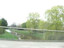
 The Steinhuder Meerbach in the Meerbruch wetland near Lake Steinhude | |
| State | Lower Saxony, Germany |
| Reference no. | DE: 478 |
| Physical characteristics | |
| Main source |
Steinhuder Meer 52°28′10″N 9°16′35″E / 52.46944°N 9.27639°E |
| River mouth |
near Nienburg into the Weser 52°38′10″N 9°12′16″E / 52.63625°N 9.20444°ECoordinates: 52°38′10″N 9°12′16″E / 52.63625°N 9.20444°E |
| Length | 34.4 km (21.4 mi) [1] |
| Basin features | |
| Progression | Weser→ North Sea |
| Basin size | 356 km2 (137 sq mi) [1] |
| Landmarks |
|
The Steinhuder Meerbach is a 34 km long orographically right-hand tributary of the River Weser in the German federal state of Lower Saxony.
Names
Some people simply call it Meerbach. Within the town of Nienburg the Meerbach is also commonly known as the Aue, and in the neighbouring villages to the south also as the Bäke.
Course
The Steinhuder Meerbach is the natural tailstream of Lake Steinhude. Its channel flow significantly exceeds the inflow of above-ground headstreams of the lake. It leaves the lake at its northwestern end and then flows west through the Meerbruch nature reserve and the village of Rehburg. It then swings northwards and empties, after 29 km, into the Weser at Nienburg.
The Steinhuder Meerbach is canalised along almost its entire length.
At the point where the river bends sharply to the west in Nienburg shortly before its confluence with the Weser the Steinhuder Meerbach used to flow further to the northeast and discharge into the River Aller at Rethem. Today the Schipsegraben ditch runs along the old river course.