Stavne
| Stavne | |
|---|---|
| Neighborhood in Trondheim | |
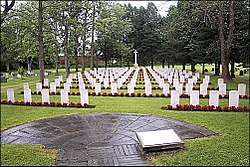 View of the neighborhood Stavne Cemetery | |
 Stavne Location of the neighborhood  Stavne Stavne (Norway) | |
| Coordinates: 63°24′42″N 10°23′05″E / 63.4118°N 10.3848°ECoordinates: 63°24′42″N 10°23′05″E / 63.4118°N 10.3848°E | |
| Country | Norway |
| Region | Central Norway |
| County | Trøndelag |
| Municipality | Trondheim |
| Borough | Midtbyen |
| Elevation[1] | 22 m (72 ft) |
| Time zone | UTC+01:00 (CET) |
| • Summer (DST) | UTC+02:00 (CEST) |
Stavne is a neighbourhood in the city of Trondheim in Trøndelag county, Norway. It is located in the borough of Midtbyen. It is located on the west shore of the river Nidelva, east of Byåsen. It lies across the river from Elgeseter. The area was previously served the Dovre Line. It is presently served by the Stavne–Leangen Line which runs between Stavne and Leangen.[2]
Stavne is the location of Trondheim (Stavne) Cemetery which is maintanied by the Commonwealth War Graves Commission. [3]
References
- ↑ "Stavne, Trondheim (Trøndelag)". yr.no. Retrieved 2018-03-21.
- ↑ Mæhlum, Lars, ed. (2013-12-23). "Stavne-Leangenbanen". Store norske leksikon (in Norwegian). Kunnskapsforlaget. Retrieved 2018-03-21.
- ↑ "Trondheim (Stavne) Cemetery". Commonwealth War Graves Commission. Retrieved 2016-12-01.

This article is issued from
Wikipedia.
The text is licensed under Creative Commons - Attribution - Sharealike.
Additional terms may apply for the media files.