Stattegg
| Stattegg | ||
|---|---|---|
 | ||
| ||
 Stattegg Location within Austria
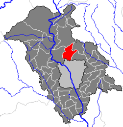
Location within Graz-Umgebung district
| ||
| Coordinates: 47°08′14″N 15°25′12″E / 47.13722°N 15.42000°ECoordinates: 47°08′14″N 15°25′12″E / 47.13722°N 15.42000°E | ||
| Country | Austria | |
| State | Styria | |
| District | Graz-Umgebung | |
| Government | ||
| • Mayor | Karl Zimmermann (ÖVP) | |
| Area | ||
| • Total | 25.88 km2 (9.99 sq mi) | |
| Elevation | 432 m (1,417 ft) | |
| Population (1 January 2016)[1] | ||
| • Total | 2,847 | |
| • Density | 110/km2 (280/sq mi) | |
| Time zone | UTC+1 (CET) | |
| • Summer (DST) | UTC+2 (CEST) | |
| Postal code | 8046 | |
| Area code | 0316 | |
| Vehicle registration | GU | |
| Website |
www.stattegg. steiermark.at | |

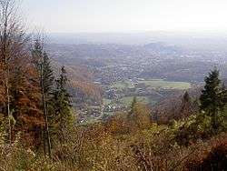
Stattegg is a village and a suburb of Graz, the capital of the Austrian state of Styria. It lies at the bottom of the Schoeckl, a mountain of the European Alps. Stattegg has 2580 inhabitants (as of 31 December 2005) and consists of 13 Katastralgemeinden: Buch, Eichberg, Hochgreit, Hohenberg, Hub, Kalkleiten, Krail, Leber, Mühl, Neudorf, Rannach, Steingraben, Ursprung.
History
In medieval times the Stadecker were a dynasty of ministeriales in the service of the sovereign of Styria. Their seat was the castle of Stadeck located in Hub, a part of Stattegg. Ulrich I von Stadeck was 26th arch bishop of Salzburg (1256–1265), Rudolf von Stadegge was a minstrel, several were Landeshauptmann of Styria. 1400 the dynasty ended with Hans and Leuthold of Stadeck.[2]
Objects of Interest
- Church Maria Schutz in Kalkleiten
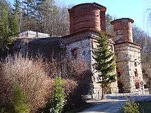
- Old limekiln (founded 1890, stopped 1966, classified as a historical monument since 1981)
- Well of Andritz-Ursprung ( Jakob- Lorber Begegnungsstätte )
External links
References
- ↑ Statistik Austria - Bevölkerung zu Jahresbeginn 2002-2016 nach Gemeinden (Gebietsstand 1.1.2016) for Stattegg.
- ↑ Friedrich Stehlik: "Stattegg", Eigenverlag der Gemeinde Stattegg, 1984