Sankt Oswald bei Plankenwarth
| Sankt Oswald bei Plankenwarth | ||
|---|---|---|
| ||
 Sankt Oswald bei Plankenwarth Location within Austria
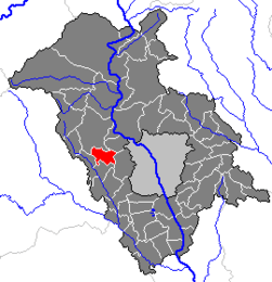
Location within Graz-Umgebung district
| ||
| Coordinates: 47°04′47″N 15°16′47″E / 47.07972°N 15.27972°ECoordinates: 47°04′47″N 15°16′47″E / 47.07972°N 15.27972°E | ||
| Country | Austria | |
| State | Styria | |
| District | Graz-Umgebung | |
| Government | ||
| • Mayor | Andreas Staude (SPÖ) | |
| Area | ||
| • Total | 11.75 km2 (4.54 sq mi) | |
| Elevation | 557 m (1,827 ft) | |
| Population (1 January 2016)[1] | ||
| • Total | 1,202 | |
| • Density | 100/km2 (260/sq mi) | |
| Time zone | UTC+1 (CET) | |
| • Summer (DST) | UTC+2 (CEST) | |
| Postal code | 8113 | |
| Area code | 03123 | |
| Vehicle registration | GU | |
| Website | www.sanktoswald.net | |

Sankt Oswald bei Plankenwarth is a municipality in the district of Graz-Umgebung in the Austrian state of Styria.
Population
| Historical population | ||
|---|---|---|
| Year | Pop. | ±% |
| 1869 | 770 | — |
| 1880 | 800 | +3.9% |
| 1890 | 797 | −0.4% |
| 1900 | 762 | −4.4% |
| 1910 | 792 | +3.9% |
| 1923 | 802 | +1.3% |
| 1934 | 769 | −4.1% |
| 1939 | 700 | −9.0% |
| 1951 | 777 | +11.0% |
| 1961 | 761 | −2.1% |
| 1971 | 754 | −0.9% |
| 1981 | 850 | +12.7% |
| 1991 | 1,006 | +18.4% |
| 2001 | 1,135 | +12.8% |
References
- ↑ Statistik Austria - Bevölkerung zu Jahresbeginn 2002-2016 nach Gemeinden (Gebietsstand 1.1.2016) for Sankt Oswald bei Plankenwarth.
This article is issued from
Wikipedia.
The text is licensed under Creative Commons - Attribution - Sharealike.
Additional terms may apply for the media files.