Arizona State Route 73
| ||||
|---|---|---|---|---|
 | ||||
| Route information | ||||
| Maintained by ADOT | ||||
| Length | 46.79 mi[1] (75.30 km) | |||
| Existed | 1927 – present | |||
| Tourist routes |
| |||
| Major junctions | ||||
| CW end |
| |||
| CCW end |
| |||
| Location | ||||
| Counties | Navajo, Gila | |||
| Highway system | ||||
| ||||

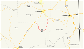
State Route 73, also known as SR 73, is a north–south state highway primarily serving the Fort Apache Indian Reservation in eastern Arizona. SR 73 begins at a junction with the U.S. Route 60 / State Route 77 concurrency near Carrizo, travels southeast to Fort Apache and Whiteriver, then bends north-northeast until intersecting State Route 260 near the Hon-Dah Resort Casino.
Apart from its termini, the current SR 73 intersects no other US or state routes.
Route description
The clockwise (southern) terminus of SR 73 is located at a junction with US 60 southwest of Show Low. From this intersection, the highway heads southeast within the Fort Apache Indian Reservation. It passes through Cedar Creek and curves towards the east before passing through Canyon Day. Continuing towards the east, it reaches Fort Apache, where it turns towards the northeast. It continues to the northeast on to Whiteriver, where it begins to head towards more of a northerly direction. It continues north through the Fort Apache Indian Reservation until it reaches its counterclockwise (northern) terminus at a junction with SR 260 east of McNary.[1][3]
History
SR 73 was designated as one of the original state routes from the current western terminus to McNary. In 1929, it extended to Springerville. In 1972, portions were transferred to SR 260.
Junction list
| County | Location | mi[1] | km | Destinations | Notes | |||
|---|---|---|---|---|---|---|---|---|
| Navajo | | 0.00 | 0.00 | Clockwise terminus | ||||
| Gila |
No major junctions | |||||||
| Navajo | | 46.79 | 75.30 | Counterclockwise terminus; access to Sunrise Ambulatory Surgical Center | ||||
| 1.000 mi = 1.609 km; 1.000 km = 0.621 mi | ||||||||
References
- 1 2 3 Arizona Department of Transportation. "ADOT Highway Log" (PDF). Archived from the original (PDF) on May 18, 2007. Retrieved July 16, 2007.
- ↑ Arizona Department of Transportation (2014). "Arizona Parkways, Historic and Scenic Roads" (PDF). Phoenix: Arizona Department of Transportation. Retrieved September 11, 2018.
- ↑ Google (2008-04-23). "overview map of SR 73" (Map). Google Maps. Google. Retrieved 2008-04-23.
External links
Route map: