Texas State Highway 242
| ||||
|---|---|---|---|---|
 | ||||
| Route information | ||||
| Maintained by TxDOT | ||||
| Length | 21.633 mi[1] (34.815 km) | |||
| Existed | 1985–present | |||
| Major junctions | ||||
| West end |
| |||
|
| ||||
| East end |
| |||
| Location | ||||
| Counties | Montgomery | |||
| Highway system | ||||
| ||||

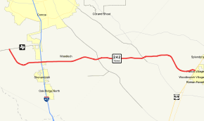
State Highway 242 (SH 242) is a Texas state highway connecting The Woodlands and Patton Village in southeast Texas.
Route description
SH 242 begins at FM 1488 in The Woodlands.[2] The roadway, also known locally as College Park Drive, curves to the southeast and passes to the south of W. G. Jones State Forest. It then turns to the east and crosses I-45 in the southern outskirts of Conroe. The route continues to the east, crossing FM 1314 and FM 1485, before reaching its eastern terminus at I-69 / US 59 in Patton Village.[3]
History
SH 242 was originally designated on December 22, 1936 as a route from Hempstead to Sugarland.[4] This route was deleted on September 26, 1939, as it became part of SH 6. SH 242 was designated between I-45 and US 59 (now dual-signed as I-69/US 59) on May 22, 1985. The westward extension to FM 1488 was designated on May 29, 1986.[1] Two direct-connect flyover ramps connecting SH 242 westbound to southbound I-45 and northbound I-45 to westbound SH 242 were constructed in 2015. The flyovers are tolled ramps, using electronic toll collection tags and no cash, that were opened to the public around May 11, 2015, and were toll-free until July 6, 2015, when the Harris County Toll Road Authority (HCTRA) began collecting toll fees for the Montgomery County Toll Road Authority (MCTRA) as a part of a collaboration effort between the two entities.
Major intersections
The entire route is in Montgomery County.
| Location | mi[5] | km | Destinations | Notes | |
|---|---|---|---|---|---|
| The Woodlands | 0.0 | 0.0 | Western terminus | ||
| Conroe | 4.4 | 7.1 | I-45 exit 79 southbound; 79A (Free) & 79B (Toll Ramp) northbound. | ||
| | 10.5 | 16.9 | |||
| | 15.2 | 24.5 | |||
| Patton Village | 21.6 | 34.8 | I-69/US 59 exit 161; eastern terminus | ||
| 1.000 mi = 1.609 km; 1.000 km = 0.621 mi | |||||
References
- 1 2 Transportation Planning and Programming Division (n.d.). "State Highway No. 242". Highway Designation Files. Texas Department of Transportation. Retrieved 2008-04-04.
- ↑ Transportation Planning and Programming Division (2012). Texas County Mapbook (PDF) (Map) (2012 ed.). 1:120,000. Texas Department of Transportation. p. 560. OCLC 867856197. Retrieved 2011-11-25.
- ↑ Transportation Planning and Programming Division (2012). Texas County Mapbook (PDF) (Map) (2012 ed.). 1:120,000. Texas Department of Transportation. p. 580. OCLC 867856197. Retrieved 2011-11-25.
- ↑ "Minutes of the December 21, 1936 State Highway Commission meeting" (PDF).
- ↑ Google (2011-11-25). "State Highway 242" (Map). Google Maps. Google. Retrieved 2011-11-25.