Star Tower
- You may also be looking for the Gangnam Finance Center, Seoul, Korea.
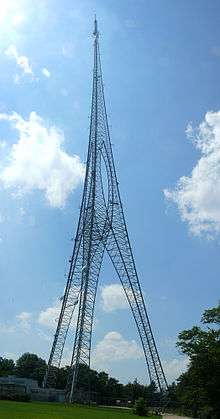
Star Tower is a digital television and FM radio transmitting tower on Winton Road near North Bend Road in the College Hill neighborhood of Cincinnati, Ohio. The three-legged lattice tower stands 954 feet (290.8 m) high. It was the 47th tallest tower in the world and is currently the tallest tower in Cincinnati, Ohio. It was built for WSTR-TV, known as "Star64".[1][2]
An omnidirectional antenna[3] atop Star Tower transmits the signal of owner WSTR-TV,[4] while a number of FM radio stations, including WREW,[5] WGRR,[6] and WYGY[7] also broadcast from the tower. WRRM[8] has a backup antenna located on this tower; their primary is on the WXIX tower closer to the center of Cincinnati.[6]
The Landmark Tower Company of Fort Worth, Texas, which built Star Tower using a Sikorsky S-64 helicopter, was responsible for several similar structures around the country, including the Mesquite Tower in Mesquite, Texas; the Hughes Memorial Tower in Washington, D.C.; and at a smaller scale, WPXR-TV's analog antenna on Poor Mountain in Virginia. A small version of the tower can be found atop the Energy Plaza skyscraper in downtown Dallas, used by TXU for its communications needs. Landmark went bankrupt after its owner and chief design engineer, Hank McGinnis, died from a massive heart attack in 2002.[9]
References
- ↑ "Listing 1014277". Antenna Structure Registration database. U.S. Federal Communications Commission.
- ↑ "Listing 1014132". Antenna Structure Registration database. U.S. Federal Communications Commission.
- ↑ "WSTR Upgrades Power, Signal Strength". TVNewsCheck. 2009-09-24. Retrieved 2009-09-27.
- ↑ Query the FCC's TV station database for WSTR
- ↑ Query the FCC's FM station database for WREW
- 1 2 Query the FCC's FM station database for WGRR
- ↑ Query the FCC's FM station database for WYGY
- ↑ Query the FCC's FM station database for WRRM
- ↑ http://www.wirelessestimator.com/t_content.cfm?pagename=Wireless%20Tower%20News
External links
Coordinates: 39°12′01″N 84°31′22″W / 39.20028°N 84.52278°W