Staré Město pod Landštejnem
| Staré Město pod Landštejnem | |||
|---|---|---|---|
| Market town | |||
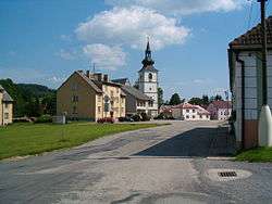 Town center | |||
| |||
 Staré Město pod Landštejnem | |||
| Coordinates: 49°00′12″N 15°15′14″E / 49.0034°N 15.2538°ECoordinates: 49°00′12″N 15°15′14″E / 49.0034°N 15.2538°E | |||
| Country |
| ||
| Region | South Bohemian | ||
| District | Jindřichův Hradec | ||
| Area | |||
| • Total | 69.19 km2 (26.71 sq mi) | ||
| Elevation | 545 m (1,788 ft) | ||
| Population (January 2014)[1] | |||
| • Total | 490 | ||
| • Density | 7.1/km2 (18/sq mi) | ||
| Time zone | UTC+1 (CET) | ||
| • Summer (DST) | UTC+2 (CEST) | ||
| Postal code | 378 81 to 378 82 | ||
| NUTS 5 (municipality) | CZ0313 547212 | ||
| Website | Official website | ||


Staré Město pod Landštejnem (German: Altstadt) is a market town (městys) in Jindřichův Hradec District in the South Bohemian Region of the Czech Republic.
The municipality covers an area of 69.19 square kilometres (26.71 sq mi), and has a population of 490 inhabitants as of 1 January 2014.
Staré Město pod Landštejnem lies approximately 27 kilometres (17 mi) south-east of Jindřichův Hradec, 58 km (36 mi) east of České Budějovice, and 137 km (85 mi) south-east of Prague.
References
| Wikimedia Commons has media related to Staré Město pod Landštejnem. |
This article is issued from
Wikipedia.
The text is licensed under Creative Commons - Attribution - Sharealike.
Additional terms may apply for the media files.