Český Rudolec
| Český Rudolec | ||
|---|---|---|
| Municipality | ||
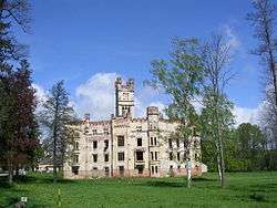 Castle in the village | ||
| ||
 Český Rudolec | ||
| Coordinates: 49°3′56″N 15°19′12″E / 49.06556°N 15.32000°ECoordinates: 49°3′56″N 15°19′12″E / 49.06556°N 15.32000°E | ||
| Country |
| |
| Region | South Bohemian | |
| District | Jindřichův Hradec | |
| Area | ||
| • Total | 49.22 km2 (19.00 sq mi) | |
| Elevation | 511 m (1,677 ft) | |
| Population (2007) | ||
| • Total | 967 | |
| • Density | 20/km2 (51/sq mi) | |
| Postal code | 378 53 to 380 01 | |
| Website | http://www.ceskyrudolec.cz | |
Český Rudolec (German: Böhmisch Rudoletz) is a village and municipality (obec) in Jindřichův Hradec District in the South Bohemian Region of the Czech Republic.
The municipality covers an area of 49.22 square kilometres (19.00 sq mi), and has a population of 967 (as at 31 December 2007).
Český Rudolec lies approximately 26 kilometres (16 mi) east of Jindřichův Hradec, 63 km (39 mi) east of České Budějovice, and 131 km (81 mi) south-east of Prague.
References
| Wikimedia Commons has media related to Český Rudolec. |
This article is issued from
Wikipedia.
The text is licensed under Creative Commons - Attribution - Sharealike.
Additional terms may apply for the media files.