Stará Ľubovňa District
| Stará Ľubovňa District | |
|---|---|
| District | |
 | |
| Country | Slovakia |
| Region (kraj) | Prešov Region |
| Area | |
| • Total | 624 km2 (241 sq mi) |
| Population (2001) | |
| • Total | 50,684 |
| • Density | 81/km2 (210/sq mi) |
| Time zone | UTC+1 (CET) |
| • Summer (DST) | UTC+2 (CEST) |
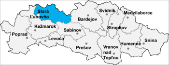
Stará Ľubovňa District (okres Stará Ľubovňa) is a district in the Prešov Region of eastern Slovakia. Until 1918, the district was almost entirely part of the county of Kingdom of Hungary of Spiš, apart from a small area in the east which formed part of the county of Šariš.
Municipalities
- Čirč
- Ďurková
- Forbasy
- Hajtovka
- Haligovce
- Hniezdne
- Hraničné
- Hromoš
- Chmeľnica
- Jakubany
- Jarabina
- Kamienka
- Kolačkov
- Kremná
- Kyjov
- Lacková
- Legnava
- Lesnica
- Litmanová
- Lomnička
- Ľubotín
- Malý Lipník
- Matysová
- Mníšek nad Popradom
- Nižné Ružbachy
- Nová Ľubovňa
- Obručné
- Orlov
- Plaveč
- Plavnica
- Podolínec
- Pusté Pole
- Ruská Voľa nad Popradom
- Stará Ľubovňa
- Starina
- Stráňany
- Sulín
- Šambron
- Šarišské Jastrabie
- Údol
- Veľká Lesná
- Veľký Lipník
- Vislanka
- Vyšné Ružbachy
Districts of Prešov Region | ||
|---|---|---|
This article is issued from
Wikipedia.
The text is licensed under Creative Commons - Attribution - Sharealike.
Additional terms may apply for the media files.