Stacy Fork, Kentucky
| Stacy Fork | |
|---|---|
| Unincorporated community | |
 Stacy Fork Location within the state of Kentucky  Stacy Fork Stacy Fork (the US) | |
| Coordinates: 37°50′29″N 83°15′27″W / 37.84139°N 83.25750°WCoordinates: 37°50′29″N 83°15′27″W / 37.84139°N 83.25750°W | |
| Country | United States |
| State | Kentucky |
| County | Morgan |
| Elevation | 823 ft (251 m) |
| Time zone | UTC-5 (Eastern (EST)) |
| • Summer (DST) | UTC-4 (EDT) |
| ZIP codes | 41458 |
| GNIS feature ID | 509116 |
Stacy Fork is an unincorporated community in Morgan County, Kentucky, United States. It lies along Route 191 south of the city of West Liberty, the county seat of Morgan County.[1] Its elevation is 823 feet (251 m).[2]
The community's name is taken from the Stacy Fork, named after pioneer settler Meshack Shadrack Stacy (1792–1870), who traveled through the Cumberland Gap from Tennessee and settled the area in the early 19th century.
References
- ↑ Rand McNally. The Road Atlas '06. Chicago: Rand McNally, 2006, p. 43.
- ↑ U.S. Geological Survey Geographic Names Information System: Stacy Fork, Kentucky, Geographic Names Information System, 1979-09-20. Accessed 2008-01-03.
Municipalities and communities of Morgan County, Kentucky, United States | ||
|---|---|---|
| City | 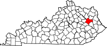 | |
| CDP | ||
| Other unincorporated communities | ||
This article is issued from
Wikipedia.
The text is licensed under Creative Commons - Attribution - Sharealike.
Additional terms may apply for the media files.