St Peters, New South Wales
| St Peters Sydney, New South Wales | |||||||||||||||
|---|---|---|---|---|---|---|---|---|---|---|---|---|---|---|---|
 Former brickworks, Sydney Park | |||||||||||||||
| Population | 3,145 (2016 census)[1] | ||||||||||||||
| Postcode(s) | 2044 | ||||||||||||||
| Location | 7 km (4 mi) south of Sydney CBD | ||||||||||||||
| LGA(s) | |||||||||||||||
| State electorate(s) | Heffron | ||||||||||||||
| Federal Division(s) | |||||||||||||||
| |||||||||||||||
St Peters is a suburb in the Inner West[2] of Sydney, in the state of New South Wales, Australia. It is 7 kilometres south of the Sydney central business district, in the local government area of Inner West Council.[3]
History
St Peters was named by its association with St Peters Anglican Church, which was consecrated in 1838. St Peters is the third oldest Anglican church in Sydney and has been claimed to be the first church built in Australia using non-convict labour. The church is on the Princes Highway. It was designed by Thomas Bird and built in 1838-39. In 1875, alterations were carried out under the supervision of Edmund Blacket. The church is now listed on the Register of the National Estate.[4] The graveyard is the burial place of a few notable people, including solicitor and merchant Frederick Wright Unwin, who had Unwin Road and Unwin's Bridge named after him.[5] It is also the burial place of people who committed suicide, patients of the Bayview Mental Asylum at Tempe, and victims of unsolved murders. Graveyard history tours are conducted monthly.[6]
In 2009, the church was given a grant of $30,000 from the state government for carrying out much-needed renovations. The grant was aimed at repairing cracked walls and sealing windows. Pastor Shane Rogerson said the building was "ill-fated from the beginning" because it was built on clay-based soil, which meant it will always have problems with cracking.
The first large land grant in the area was made in 1799 to Provost-Marshal Thomas Smyth. His 470 acres (1.9 km2) stretched from the Cooks River to the present Campbell Street. After Smyth's death in 1804, the land was acquired by Robert Campbell (1769–1846), a wealthy merchant who built some of the early warehouses along the Sydney Cove waterfront.
Alexander Brodie Spark (1792–1856) was a wealthy merchant who named the suburbs of Tempe after his mansion Tempe House that he built at what is now Wolli Creek and the suburb of St Peters that developed around the church. Barwon Park House was a large residence erected by Spark in 1815 on land leased from Robert Campbell. It was demolished in 1953. Campbell sold his property in 1830 but reserved land for the church. St Peters was described in the 1840s as one of the most fashionable and aristocratic suburbs of Sydney.
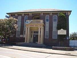
St Peters was a separate municipality from 1871 to 1948, when it amalgamated with the Municipality of Marrickville but now falls under the governance of Inner West Council. The St Peters town hall in Unwins Bridge Road was built in 1927 just across the suburb boundary in Sydenham and now houses the St Peters branch of Inner West Library and a small community centre. The railway station opened on 15 October 1884 and the post office opened in October 1851.[7]
Brickworks
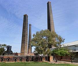
In the 1870s, St Peters was an important brickmaking centre with a large brickworks on the site now known as Sydney Park, on the corner of Mitchell Road (now Sydney Park Road) and the Princes Highway, close to St Peters railway station. The brickworks closed after World War II and for most of the 1960s and 1970s the site was used as a rubbish tip, with the vast clay pits eventually filled by domestic and commercial refuse. After the tip closed in the 1980s, Sydney Park was created on the site. The area was covered, landscaped and revegetated so that several large artificial hills were created with sweeping views south to Botany Bay and north to the city. Four towering chimneys that carried exhaust from the brick kilns remain standing and have been incorporated into the Sydney Park site along with some of the kilns and various pieces of large brickworks machinery. The remains of the brickworks were heritage-listed.[8]
The brickworks are well known in paleontology for the discovery of a full, intact skeleton of a Paracyclotosaurus davidi in 1910.[9] The Paracyclotosaurus davidi was a prehistoric amphibian and the only known species to have lived in Australia.[10]
Heritage listings
St Peters has a number of heritage-listed sites, including:
- 187-209 Princes Highway: St Peter's Anglican Church[11]
- Princes Highway (opposite Sydney Park Road): St Peters railway station[12]
Population
According to the 2016 census, there were 3,145 residents in St Peters. 62.4% of residents were born in Australia. The next most common country of birth was England (5.2%). 72% of people only spoke English at home. The most common responses for religious affiliation were No Religion (49.3%) and Catholic (26.6%).[1]
Transport
The Princes Highway is a major arterial road in southern Sydney. It has its origins in St Peters at the intersection with King Street and Sydney Park Road. Also located at this intersection is St Peters railway station which is served by trains on the Bankstown Line of the Sydney Trains network. City-bound trains arrive approximately every fifteen minutes in peak hour, and take about seven minutes to reach Central station. State Transit service St Peters with the Tempe-bound 422 from Circular Quay and the Coogee-bound 370 from Leichhardt.
Commercial area
St Peters has a mixture of residential, commercial and industrial areas. The main shopping strip is located along the Princes Highway, leading into King Street, Newtown.
Landmarks
- Sydney Park is a large recreation area close to the intersection of the Princes Highway, King Street and Sydney Park Road. Camdenville Oval sits between May Street and the railway line.
- St Peters is the home of the Town and Country Hotel, immortalised in the song "Duncan" recorded by Slim Dusty. The Southern Cross Hotel is located on the corner of Princes Highway and Canal Road.
- Olympic rings, used to decorate Sydney during the 2000 Olympics, now adorn the entrance to a recycling centre at St Peters.
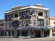 Town and Country Hotel, Unwins Bridge Road
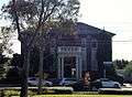 St Peters Town Hall, Unwins Bridge Road
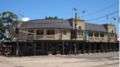 Southern Cross Hotel, Princes Highway
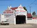 Garage on Princes Highway
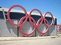 Olympic rings outside St Peters Recycling Centre
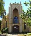 St Peters Church
 Zenix, Sydney Park Road
Schools
St Peters Public School was built in 1881 by the Anglican church and became public in the mid-1950s. Although the school has had its hardships with its student population declining, it still remains to this day.
References
- 1 2 Australian Bureau of Statistics (27 June 2017). "St Peters". 2016 Census QuickStats. Retrieved 5 July 2017.

- ↑ Australian Suburb Guide: Sydney Inner West Archived 26 December 2012 at the Wayback Machine. Retrieved 7 August 2013.
- ↑ Gregory's Sydney Street Directory, Gregory's Publishing Company, 2007
- ↑ The Heritage of Australia, Macmillan Company, 1981, p.2/44
- ↑ "Unwin, Frederick Wright | The Dictionary of Sydney". dictionaryofsydney.org. Retrieved 2018-01-30.
- ↑ Inner West Courier, 2013-5-7, p.8
- ↑ Book of Sydney Suburbs, Frances Pollon (Angus and Robertson) 1990, page 239
- ↑ State Heritage Register
- ↑ The Journal of Paleontology, "Triassic isopod Protamphisopus wianamattensis (Chilton) and comparison with extant taxa (Crustacea, phreatoicidea)". Retrieved 21 June 2007.
- ↑ The Natural History Museum, London, "Paracyclotosaurus davidi - Dinosaurs and Extinct Species, Fish & Amphibians at The Natural History Museum, London". Retrieved 21 June 2007.
- ↑ "St. Peter's Anglican Church, New South Wales State Heritage Register (NSW SHR) Number H00032". New South Wales State Heritage Register. Office of Environment and Heritage. Retrieved 18 May 2018.
- ↑ "St Peters Railway Station Group, New South Wales State Heritage Register (NSW SHR) Number H01250". New South Wales State Heritage Register. Office of Environment and Heritage. Retrieved 18 May 2018.
| Wikimedia Commons has media related to St Peters, New South Wales. |
External links
Coordinates: 33°54′34″S 151°10′38″E / 33.90951°S 151.17723°E