St Neots Rural District
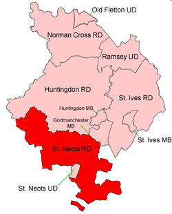
Coordinates: 52°16′N 0°16′W / 52.26°N 0.26°W St Neots was a rural district in Huntingdonshire from 1894 to 1974, around the northern and eastern sides of the urban area of St Neots.
It was formed under the Local Government Act 1894 from that part of the St. Neots rural sanitary district which was in Huntingdonshire (the rest forming Eaton Socon Rural District in Bedfordshire).
It was expanded in 1935 by taking in Covington parish from the disbanded Thrapston Rural District.
In 1965 Huntingdonshire and the Soke of Peterborough merged to form Huntingdon and Peterborough.
In 1974 the district was abolished under the Local Government Act 1972 and became part of the non-metropolitan district of Huntingdon, subsequently renamed Huntingdonshire. A small area was transferred to Bedfordshire.
Parishes[1]
| Parish | From | To | Notes |
|---|---|---|---|
| Abbotsley | |||
| Buckden | |||
| Catworth | |||
| Covington | 1935 | Previously in Thrapston RD | |
| Diddington | |||
| Eynesbury Hardwicke | From 1894-1895 part of a single Eynesbury parish. Includes a part detached from the rest of the district | ||
| Grafham | |||
| Great Gransden | |||
| Great Paxton | |||
| Great Staughton | |||
| Hail Weston | |||
| Kimbolton | |||
| Little Paxton | |||
| Midloe | 1935 | See Southoe and Midloe | |
| Offord Cluny | |||
| Offord D'Arcy | |||
| Perry | |||
| Southoe and Midloe | 1935 | Merger of Southoe & Midloe | |
| Southoe | 1935 | ||
| St Neots Rural | From 1894-1895 part of a single St Neots parish | ||
| Stow Longa | |||
| Tetworth | |||
| Tilbrook | |||
| Toseland | |||
| Waresley | |||
| Yelling |
References
- ↑ "St Neots RD through time: Census tables with data for the Local Government District". A Vision of Britain through Time. GB Historical GIS / University of Portsmouth. Retrieved 11 June 2017.