St. James, Minnesota
| St. James, Minnesota | |
|---|---|
| City | |
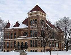 The Watonwan County Courthouse in St. James | |
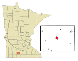 Location of St. James within Watonwan County and state of Minnesota | |
| Coordinates: 43°58′56″N 94°37′41″W / 43.98222°N 94.62806°WCoordinates: 43°58′56″N 94°37′41″W / 43.98222°N 94.62806°W | |
| Country | United States |
| State | Minnesota |
| County | Watonwan |
| Government | |
| • Type | Mayor – Council |
| • Mayor | Gary Sturm |
| Area[1] | |
| • Total | 2.43 sq mi (6.29 km2) |
| • Land | 2.40 sq mi (6.22 km2) |
| • Water | 0.03 sq mi (0.08 km2) |
| Elevation | 1,079 ft (329 m) |
| Population (2010)[2] | |
| • Total | 4,605 |
| • Estimate (2016)[3] | 4,447 |
| • Density | 1,900/sq mi (730/km2) |
| Time zone | UTC-6 (Central (CST)) |
| • Summer (DST) | UTC-5 (CDT) |
| FIPS code | 27-57040[4] |
| GNIS feature ID | 0650613[5] |
| Website | www.ci.stjames.mn.us |
St. James is a city in and the county seat of Watonwan County, Minnesota, United States.[6] The population was 4,605 at the 2010 census.[7]
Minnesota State Highways 4, 30, and 60 are three of the main routes in the city.
History
In 1870, the directors of the St. Paul and Sioux City railroads chose the future townsite of St. James as the midpoint for a new railroad linking the two cities. Named for James Purington, an early settler,[8] the new city was incorporated in 1871.[9] It was the hometown of Minnesota Governor Winfield Scott Hammond, a Democrat who served in 1915. In the 1940s, Theodore S. Mondale, the father of future Vice President of the United States Walter Mondale, was the pastor at First Methodist Church of St. James. Tony Downs Foods Co. has been a major employer since 1947, processing poultry and frozen meals.
St. James contains two properties listed on the National Register of Historic Places: the Grand Opera House (completed in 1892) and the Watonwan County Courthouse (completed in 1896).[10]
Geography
According to the United States Census Bureau, the city has a total area of 2.43 square miles (6.29 km2); 2.40 square miles (6.22 km2) is land and 0.03 square miles (0.08 km2) is water.[1]
Demographics
| Historical population | |||
|---|---|---|---|
| Census | Pop. | %± | |
| 1880 | 444 | — | |
| 1890 | 939 | 111.5% | |
| 1900 | 2,607 | 177.6% | |
| 1910 | 2,102 | −19.4% | |
| 1920 | 2,673 | 27.2% | |
| 1930 | 2,808 | 5.1% | |
| 1940 | 3,400 | 21.1% | |
| 1950 | 3,861 | 13.6% | |
| 1960 | 4,174 | 8.1% | |
| 1970 | 4,027 | −3.5% | |
| 1980 | 4,346 | 7.9% | |
| 1990 | 4,364 | 0.4% | |
| 2000 | 4,695 | 7.6% | |
| 2010 | 4,605 | −1.9% | |
| Est. 2016 | 4,447 | [3] | −3.4% |
| U.S. Decennial Census | |||
2010 census
As of the census[2] of 2010, there were 4,605 people, 1,839 households, and 1,145 families residing in the city. The population density was 1,918.8 inhabitants per square mile (740.9/km2). There were 2,039 housing units at an average density of 849.6 per square mile (328.0/km2). The racial makeup of the city was 81.8% White, 0.7% African American, 0.9% Native American, 0.6% Asian, 14.9% from other races, and 1.1% from two or more races. Hispanic or Latino of any race were 31.0% of the population.
There were 1,839 households of which 32.2% had children under the age of 18 living with them, 45.8% were married couples living together, 11.0% had a female householder with no husband present, 5.4% had a male householder with no wife present, and 37.7% were non-families. 33.4% of all households were made up of individuals and 17.1% had someone living alone who was 65 years of age or older. The average household size was 2.47 and the average family size was 3.17.
The median age in the city was 37.8 years. 27.8% of residents were under the age of 18; 7.3% were between the ages of 18 and 24; 23.6% were from 25 to 44; 23.3% were from 45 to 64; and 17.9% were 65 years of age or older. The gender makeup of the city was 48.7% male and 51.3% female.
2000 census
As of the census[4] of 2000, there were 4,695 people, 1,845 households, and 1,186 families residing in the city. The population density was 2,050.3 people per square mile (791.6/km²). There were 2,006 housing units at an average density of 876.0 per square mile (338.2/km²). The racial makeup of the city was 83.24% White, 0.40% African American, 0.15% Native American, 0.51% Asian, 14.27% from other races, and 1.43% from two or more races. Hispanic or Latino of any race were 23.77% of the population.
There were 1,845 households out of which 32.1% had children under the age of 18 living with them, 51.1% were married couples living together, 9.6% had a female householder with no husband present, and 35.7% were non-families. 32.0% of all households were made up of individuals and 17.7% had someone living alone who was 65 years of age or older. The average household size was 2.50 and the average family size was 3.16.
In the city, the population was spread out with 27.9% under the age of 18, 9.5% from 18 to 24, 23.9% from 25 to 44, 20.0% from 45 to 64, and 18.7% who were 65 years of age or older. The median age was 35 years. For every 100 females, there were 88.9 males. For every 100 females age 18 and over, there were 86.4 males.
The median income for a household in the city was $33,196, and the median income for a family was $40,993. Males had a median income of $30,036 versus $19,391 for females. The per capita income for the city was $15,336. About 9.0% of families and 10.8% of the population were below the poverty line, including 16.5% of those under age 18 and 9.9% of those age 65 or over.
Notable people
- Moses K. Armstrong, businessman and legislator
- Peter Eckerstrom, Arizona Court of Appeals judge
- Henry Norman Graven (1893-1970), United States District Court judge, was born in St. James.
- Winfield Scott Hammond (1863–1915) 18th Minnesota Governor 1915, established his home and his law practice in St. James.
- Mike Kingery, born March 29, 1961 in St. James, Minnesota, is a former professional baseball player who played in the Major Leagues primarily as an outfielder from 1986–1992 and 1994–1996.
- Lowell John Bean, born in St. James on April 26, 1931. Professor of Anthropology, author of many books and articles about California Indians.
References
- 1 2 "US Gazetteer files 2010". United States Census Bureau. Archived from the original on 2012-01-24. Retrieved 2012-11-13.
- 1 2 "American FactFinder". United States Census Bureau. Retrieved 2012-11-13.
- 1 2 "Population and Housing Unit Estimates". Retrieved June 9, 2017.
- 1 2 "American FactFinder". United States Census Bureau. Retrieved 2008-01-31.
- ↑ "US Board on Geographic Names". United States Geological Survey. 2007-10-25. Retrieved 2008-01-31.
- ↑ "Find a County". National Association of Counties. Retrieved 2011-06-07.
- ↑ "2010 Census Redistricting Data (Public Law 94-171) Summary File". American FactFinder. United States Census Bureau. Retrieved 27 April 2011.
- ↑ Chicago and North Western Railway Company (1908). A History of the Origin of the Place Names Connected with the Chicago & North Western and Chicago, St. Paul, Minneapolis & Omaha Railways. p. 165.
- ↑ Upham, Warren (1920). Minnesota Geographic Names: Their Origin and Historic Significance. Minnesota Historical Society. p. 576.
- ↑ "Minnesota National Register Properties Database". Minnesota Historical Society. 2009. Retrieved 2017-12-29.
External links

- City Website
- St. James Public Schools
- St. James Chamber of Commerce
- St. James Plaindealer newspaper site
Municipalities and communities of Watonwan County, Minnesota, United States | ||
|---|---|---|
| Cities | 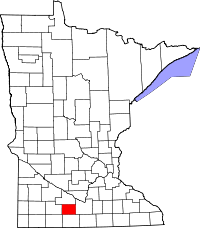 | |
| Townships | ||
| Unincorporated communities | ||
| Footnotes | ‡This populated place also has portions in an adjacent county or counties | |