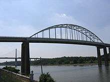
St. Georges Bridge (Delaware)
| St. Georges Bridge | |
|---|---|
 | |
| Coordinates | 39°33′09″N 75°39′04″W / 39.552568°N 75.651051°WCoordinates: 39°33′09″N 75°39′04″W / 39.552568°N 75.651051°W |
| Carries |
|
| Crosses | Chesapeake & Delaware Canal |
| Locale | St. Georges, Delaware |
| Maintained by | U.S. Army Corps of Engineers |
| Characteristics | |
| Design | Tied arch bridge |
| Total length | 4,209 feet (1,283 m) |
| Width | approx. 28 feet (8.5 m) |
| Longest span | 450 feet (140 m)[1] |
| Clearance below | 135 feet (41 m) |
| History | |
| Opened | 1942[2] |
The St. Georges Bridge is a steel tied arch bridge that carries U.S. Route 13 (US 13) across the Chesapeake & Delaware Canal in St. Georges, Delaware. Built by the U.S. Army Corps of Engineers and opened in 1942 as a high-level crossing, the bridge was the first four-lane, high-level crossing to span the canal. It replaced a previous vertical lift bridge which was damaged when a German merchant ship collided with it.
History and near replacement
On January 10, 1939, the S.S. Waukegan struck and destroyed the original St. Georges Bridge, killing the bridge tender.[3][4] The replacement steel truss St. Georges Bridge over the canal opened on January 31, 1942. This bridge was the first four-lane crossing of the Chesapeake and Delaware Canal.[4]
Prior to the opening of the paralleling Delaware Route 1 Turnpike and the Chesapeake and Delaware Canal Bridge in 1995 (renamed the Senator William V. Roth, Jr., Bridge), the bridge was the main north–south crossing in Delaware, as such, suffered from a deteriorating concrete deck and support beams that forced both the Delaware Department of Transportation (DelDOT) and the Army Corps of Engineers to place a weight restriction and forced all through truck traffic onto the paralleling Summit Bridge (U.S. Route 301), seven miles (11 km) to the west. The late U.S. Senator Bill Roth, who saw the need for a new crossing, was a main proponent in securing federal funding for the new C&D Canal Bridge.
After the opening of the paralleling C&D Canal Bridge, the Army Corps of Engineers closed the St. Georges Bridge in anticipation of demolishing the structure. Local opposition arose, especially from residents in St. Georges, whose town spans both sides of the canal; these residents would have had to travel out of their way and pay an additional toll to go from one half of the town to the other.
Instead of tearing down the bridge, the Army Corps of Engineers, using data issued from the Delaware Department of Transportation and the U.S. Census Bureau, rehabilitated the bridge between 1998 and 2001. A new concrete deck was constructed, and deteriorated beams and joints were replaced. The lead-based paint on the bridge was removed and replaced with a lead-free primer and salt-resistant enamel (the C&D Canal connects two rias, having from time to time been inundated with brackish water during dry spells), and the bridge was reopened to local traffic.
As a result of the need to maintain quick access to both U.S. 13 and the Del. Rt. 1 Turnpike, both the St. Georges Bridge and the C&D Canal Bridge have no tolls (the Army Corps of Engineers allowed DelDOT to build a South St. Georges interchange to U.S. 13 between the bridge and the Biddles Corner toll facility, with provisions to build another exit north of the bridge if needed). Prior to the mid‑1990s, the St. Georges Bridge also served as the crossing for U.S. Route 301, but this has since been shifted to the Summit Bridge along with Delaware Routes 71 and 896.
Lead Paint Incident
Lead paint exposure created a public health risk in 2000 during the sandblasting and repainting of St. George’s Bridge over the C&D Canal. The Department of Public Health (DPH) and the Department of Natural Resources and Environmental Control (DNREC) took emergency actions after wind blew lead paint chips beyond the reach of a protective tarp and onto the surrounding residential community.[5] DPH Officials began going door to door to warn residents about lead paint chipping from St. George’s Bridge in February 2000, handing out information about the dangers of lead, a guide on foods that naturally fight lead poisoning, and providing residents with information on free blood testing.[6] DNREC filed an enforcement action against the US Army Corps of Engineers in March 2000. DNREC required the USACE to 1) employ “state of the art technology” to contain falling paint chips, 2) set up a hotline for residents to report falling chips, 3) clean up fallen paint chips, 4) decontaminate soil tainted by fallen paint chips, and 5) conduct regular inspections around the bridge for any additional fallen paint chips.[7] In August 2000 DNREC calld on USACE to remove the top foot of soil from contaminated areas in 37 yards that had lead levels of 400 or more parts per million.[8]
Current Restrictions
The U.S. Army Corps of Engineers announced that beginning Tuesday, May 27, 2008, both outside lanes across the St. Georges Bridge will be closed, limiting traffic to one lane in each direction. Also, traffic will be restricted to vehicles weighing less than 15 tons.
Lane restrictions will remain in place as an extra safety measure until repairs can be made to the bridge's substructure and bearings, tentatively by the end of the calendar year. Repairs under the outside lanes will be done first. Once those are complete, the weight restriction will be lifted, the outside lanes will be reopened, and the inside lanes will be closed instead. After all repairs are completed, the bridge will be fully reopened.
During a recent inspection, the Corps identified concrete surface cracks and rebar corrosion in numerous bridge piers, along with numerous highly corroded and failing bearings under the bridge deck. None of this represents an immediate danger to the public; the overall bridge structure remains sound. However, these deteriorated conditions have reduced the margin of safety.
Lane and weight restrictions address this problem by limiting the load on the bridge, thus allowing time for the Corps to institute daily monitoring, conduct further analysis, and make the appropriate repairs to safely return the bridge to full operation.
In May 2010, conversion of the outside lanes to bike lanes was completed.
See also


- List of crossings of the Cheasapeake & Delaware Canal
References
- ↑ http://www.dnrec.state.de.us/DNREC2000/Divisions/AWM/sirb/Proposed_Plans/KLT05019.pdf
- ↑ St Georges Bridge resumes normal traffic
- ↑ Martin, Roger (January 10, 2011). "Today in Delaware History: Jan. 10". Middletown Transcript. Retrieved January 31, 2014.
- 1 2 "First Dedicated Bikes Lanes over the C & D Canal Cross St. Georges Bridge". Governor Jack Markell. Archived from the original on December 20, 2013. Retrieved January 31, 2014.
- ↑ DNREC (2007). "PROPOSED PLAN OF REMEDIAL ACTION OPERABLE UNIT 127" (PDF). State of Delaware.
- ↑ O’Sullivan, Sean (Feb 25, 2000). "St. Georges Residents Get Lead Warning". The News Journal.
- ↑ O’Sullivan, Sean (March 12, 2000). "Army Corps Directed to Contain Falling Paint Chips". The News Journal.
- ↑ Montgomery, Jeff (October 29, 2001). "State may Replace Corps for St. Georges Cleanup". The News Journal.
External links
Bridges of the Chesapeake & Delaware Canal | ||||
|---|---|---|---|---|
| ||||