Srokowo
| Srokowo | |
|---|---|
| Village | |
 Church | |
 Srokowo | |
| Coordinates: 54°12′49″N 21°31′14″E / 54.21361°N 21.52056°E | |
| Country |
|
| Voivodeship | Warmian-Masurian |
| County | Kętrzyn |
| Gmina | Srokowo |
| Population | 1,400 |
Srokowo [srɔˈkɔvɔ] (German: Drengfurth)[1] is a village in Kętrzyn County, Warmian-Masurian Voivodeship, in northern Poland, close to the border with the Kaliningrad Oblast of Russia. It is the seat of the gmina (administrative district) called Gmina Srokowo.[2] It lies approximately 17 kilometres (11 mi) north-east of Kętrzyn and 83 km (52 mi) north-east of the regional capital Olsztyn.
The village has a population of 1,400.
History
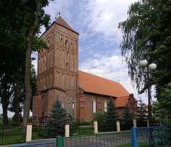
Before 1945 the area was part of the German province of East Prussia. The town was founded sometime before 1397 with a grid plan. In 1405 the town received town privileges modeled on the city law of Chełmno by the Grand Master of the Teutonic Order Konrad von Jungingen. During the Middle Ages the town defences consisted of palisades, a dry moat and three gates. Construction of the church was finished in 1409 and renovated in 1577. A school was founded in the town in 1592. A privilege of protection was proclaimed for the town in 1618 by Elector John Sigismund, whose coat of arms can still be seen on the facade of the town hall. The town was severely damaged in 1635 during the Thirty Years' War and almost completely destroyed by Tatar troops in 1657 during the Deluge. Because of its unpropitious location, the town never grew to become very large and continued to be populated mainly by farmers and artisans also during the 18th and 19th centuries.[3]
After World War II, when the town became Polish, it was renamed Dryfort in 1945, and Srokowo in 1950 after Stanisław Srokowski, the head of the Polish Committee for Settling of Place Names.[4]
References
- ↑ "Former Territory of Germany" (in German). 2017-11-11.
- ↑ "Central Statistical Office (GUS) - TERYT (National Register of Territorial Land Apportionment Journal)" (in Polish). 2008-06-01.
- ↑ Weise, Erich, ed. (1981) [1966]. Handbuch der historischen Stätten. Ost- und Westpreussen (in German). Stuttgart: Kröner. p. 42. ISBN 3-520-31701-X.
- ↑ mazury.info
| Wikimedia Commons has media related to Srokowo. |
Coordinates: 54°12′49″N 21°31′14″E / 54.21361°N 21.52056°E