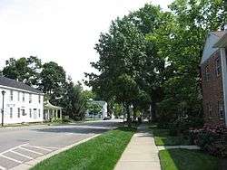
Springboro Historic District
|
Springboro Historic District | |
 | |
  | |
| Location | Roughly bounded by Main, East, and Mill Sts., and Central Ave., Springboro, Ohio |
|---|---|
| Coordinates | 39°33′18″N 84°13′57″W / 39.555°N 84.2325°WCoordinates: 39°33′18″N 84°13′57″W / 39.555°N 84.2325°W |
| Area | 50 acres (20 ha) |
| Architectural style | Federal, Greek Revival, other |
| NRHP reference # | 99000914[1] |
| Added to NRHP | August 10, 1999 |
The Springboro Historic District in Springboro, Ohio is a 50-acre (20 ha) historic district that was listed on the National Register of Historic Places in 1999.[1]
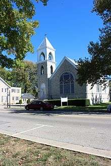
Old Stone Church
The Springboro Universalist Church or "Old Stone Church", at 300 South Main Street (39°33′11″N 84°13′59″W / 39.55306°N 84.23306°W) in the district, was built in 1905. Its congregation disbanded in the 1950s. The church building was in use by South Dayton Church of Christ in 2017.[2][3]
References
- 1 2 National Park Service (2010-07-09). "National Register Information System". National Register of Historic Places. National Park Service.
- ↑ "Springsboro Universalist Church and Cemetery".
- ↑ "History of Ohio Pioneers".
| Topics | |
|---|---|
| Lists by states |
|
| Lists by insular areas | |
| Lists by associated states | |
| Other areas | |
| |
This article is issued from
Wikipedia.
The text is licensed under Creative Commons - Attribution - Sharealike.
Additional terms may apply for the media files.