Spray Lakes Reservoir
| Spray Lakes Reservoir | |
|---|---|
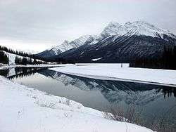 Spray Lake in winter | |
| Location | Kananaskis, Alberta |
| Coordinates | 50°54′42″N 115°20′22″W / 50.91167°N 115.33944°WCoordinates: 50°54′42″N 115°20′22″W / 50.91167°N 115.33944°W |
| Type | Reservoir |
| Primary inflows | Spray River |
| Primary outflows | Spray River |
| Basin countries |
|
| Built | 1950 |
| First flooded | 1950 |
| Max. length | 14.8 km (9.2 mi) |
| Max. width | 1.7 km (1.1 mi) |
| Surface area | 19.9 km2 (7.7 sq mi) |
| Average depth | 13.5 m (44 ft) |
| Max. depth | 65.4 m (215 ft) |
| Surface elevation | 1,701 m (5,581 ft) |
| References | Spray Lakes Reservoir |
Spray Lakes Reservoir is a reservoir in Alberta, Canada. The Spray Lakes were a string of lakes formed along the Spray River, a tributary of the Bow River. With the damming of the river, the lakes were united in the Spray Lakes Reservoir.
It lies between the Goat Range and the Three Sisters ridge, at an elevation of 1,720 meters (5,640 ft). The lake is followed by Highway 742 (Smith Dorrien Trail) in the northern part.
The lake is fed by the following waterways:
- Bryant Creek
- Turbulent Creek
- Currie Creek
- Watridge Creek
- Spray River
- Smuts Creek
- Spurling Creek
The lake is drained by the Goat Creek, which empties into the Bow River about 25 kilometers (16 mi) to the northwest, at the town of Banff.[1] Part of the water is diverted for hydroelectric purposes[2] from Goat Pond via an open canal and through a canal tunnel into Whiteman's Pond and towards Canmore.[3]
Parks
The lake lies in the recreational area of Kananaskis Country, and defines the eastern edge of Spray Valley Provincial Park. An assortment of recreational areas are established on both shores.
- Spray Lakes West Provincial Recreation Area
- Sparrowhawk Provincial Recreation Area
- Buller Mountain Provincial Recreation Area
- Mount Shark Trailhead Provincial Recreation Area
The western shore is paralleled by hiking trails, and picnic sites and campgrounds are set up on both sides of the lake.
See also
References
- ↑ Explorer's Map, Southwest Alberta, Southeast B.C., 1:500000 (5th ed.). Gem Trek Publishing. 2009. ISBN 978-1-895526-45-5.
- ↑ "TransAlta Rundle Hydroelectric Plant". Retrieved 2017-04-17.
- ↑ Canmore and Kananaskis Village Map and Trail Guide (6th ed.). Gem Trek Publishing. 2010. ISBN 978-1-895526-47-9.
