Spanish Creek (Plumas County, California)
| Spanish Creek | |
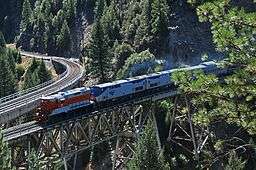 Keddie Wye bridges at Spanish Creek Canyon | |
| Country | United States |
|---|---|
| State | California |
| Source | Sierra Nevada |
| - location | Plumas National Forest |
| - elevation | 5,817 ft (1,773 m) |
| - coordinates | 39°58′06″N 121°08′32″W / 39.96833°N 121.14222°W [1] |
| Mouth | East Branch North Fork Feather River |
| - location | Paxton |
| - elevation | 2,900 ft (884 m) |
| - coordinates | 40°02′18″N 120°58′59″W / 40.03833°N 120.98306°WCoordinates: 40°02′18″N 120°58′59″W / 40.03833°N 120.98306°W [1] |
| Length | 28 mi (45 km) [1] |
 Location of Spanish Creek in California | |
Spanish Creek is a stream in the Sierra Nevada of Plumas County, California and is a tributary of the Feather River system. It flows east from headwaters in the Plumas National Forest, through Meadow Valley to Quincy where it traverses the American Valley. At the east end of the valley it turns north, flowing through a canyon towards Paxton where it joins with Indian Creek to form the East Branch North Fork Feather River.[2]
The Keddie Wye, a rail junction on the Union Pacific Railroad and popular trainspotting location is located near Keddie and consists of twin bridges across Spanish Creek. It was originally built in 1909 as part of the Feather River Route.
See also
References
- 1 2 3 "Spanish Creek". Geographic Names Information System. United States Geological Survey. 1981-01-19. Retrieved 2016-12-07.
- ↑ USGS Topo Maps for United States (Map). Cartography by United States Geological Survey. ACME Mapper. Retrieved 2016-12-07.
This article is issued from
Wikipedia.
The text is licensed under Creative Commons - Attribution - Sharealike.
Additional terms may apply for the media files.