Spanbroek
| Spanbroek | ||
|---|---|---|
| Village | ||
 | ||
| ||
 | ||
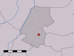 Spanbroek in the municipality of Opmeer. | ||
| Coordinates: 52°41′53″N 4°57′39″E / 52.69806°N 4.96083°ECoordinates: 52°41′53″N 4°57′39″E / 52.69806°N 4.96083°E | ||
| Country | Netherlands | |
| Province | North Holland | |
| Municipality | Opmeer | |
| Population | ||
| • Total | 4,000 | |
| Time zone | UTC+1 (CET) | |
| • Summer (DST) | UTC+2 (CEST) | |

Spanbroek is a village in the Dutch province of North Holland. It is a part of the municipality of Opmeer, and lies about 9 km (6 mi) northwest of Hoorn.[1]
Spanbroek received city rights in 1414. It was a separate municipality until 1959, when it was merged with Opmeer.[2]
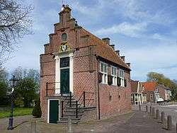
The Scheringa Museum of Realist Art is in Spanbroek.
References
- ↑ ANWB Topografische Atlas Nederland, Topografische Dienst and ANWB, 2005.
- ↑ Ad van der Meer and Onno Boonstra, Repertorium van Nederlandse gemeenten, KNAW, 2006.
External links
![]()
- J. Kuyper, Gemeente Atlas van Nederland, 1865-1870, "Spanbroek". Map of the former municipality, around 1868.
This article is issued from
Wikipedia.
The text is licensed under Creative Commons - Attribution - Sharealike.
Additional terms may apply for the media files.