Southeast, Washington, D.C.
| Southeast, Washington, D.C. Southeast | |
|---|---|
| Quadrant of Washington, D.C. | |
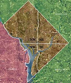 Color-enhanced USGS satellite image of Washington, D.C., taken April 26, 2002. The "crosshairs" in the image mark the quadrant divisions of Washington, with the U.S. Capitol at the center of the dividing lines. To the west of the Capitol extends the National Mall, visible as a slight green band in the image. The Northwest quadrant is the largest, located north of the Mall and west of North Capitol Street. | |
| Country |
|
| District |
|
Southeast (SE or S.E.) is the southeastern quadrant of Washington, D.C., the capital of the United States, and is located south of East Capitol Street and east of South Capitol Street. It includes the Capitol Hill and Anacostia neighborhoods, the Navy Yard, the Joint Base Anacostia-Bolling (JBAB), the U.S. Marine Barracks, the Anacostia River waterfront, Eastern Market, the remains of several Civil War-era forts, historic St. Elizabeths Hospital, RFK Stadium, Nationals Park, and the Congressional Cemetery. It is also contains a landmark known as "The Big Chair," located on Martin Luther King Avenue.[1] The quadrant is split by the Anacostia River, with the portion that is west of the river sometimes referred to as "Near Southeast".
Geography
Southeast includes the 32 neighborhoods of:
- Anacostia
- Barney Circle
- Barry Farm
- Bellevue
- Benning Ridge
- Buena Vista
- Capitol Hill
- Capitol View
- Civic Betterment
- Congress Heights
- Douglass
- Dupont Park
- Fairfax Village
- Fairlawn
- Fort Davis
- Fort Dupont
- Fort Stanton
- Garfield Heights
- Good Hope
- Greenway
- Hillcrest
- Knox Hill
- Marshall Heights
- Navy Yard
- Naylor Gardens
- Penn Branch
- Randle Highlands
- Shipley Terrace
- Skyland
- Twining
- Washington Highland
- Woodland
Government
Politically, Southeast includes most of Ward 8, as well as much of Ward 6 and Ward 7. Marion Barry, the former mayor of Washington, D.C., served as D.C. Council Member for Ward 8 until his death on November 23, 2014.[2][3]
Culture
Nationals Park, the current ballpark for Major League Baseball's Washington Nationals, opened in Southeast in March 2008.[4] Go-go music, an indigenous American art form, has a vibrant fan following in Southeast.
Transportation
Southeast Washington, D.C. is accessible via the Blue, Orange, Green and Silver Lines of the Washington Metro.[5]
Crime
In years past, the quadrant was known by some Washington, D.C. metropolitan area residents as being plagued by a high crime rate, relative to the rest of the city. For example, 14 years ago, the Washington Post reported that rock attacks on public buses were so common that bus drivers were instructed to wear safety goggles while traversing a few neighborhoods in the quadrant.[6]
Demographics
The population of Southeast is predominantly black. However, the African American population is concentrated southeast of the Anacostia River; the areas northwest of the Anacostia River are majority white. The portions of the quadrant southeast of the Anacostia are tree-lined and neighborly, although shopping, dining, entertainment, and cultural options are limited, so some residents travel either downtown or to the suburbs for such services. There are several black middle class neighborhoods in Southeast, such as Hillcrest, Penn Branch, and Fort Dupont. The areas northwest of the Anacostia contain some of the wealthiest parts of the city, including the southern half of the famous and politically connected Capitol Hill neighborhood, although these neighborhoods are plagued by rising property crime. Cultural events/activities include the annual Martin Luther King Birthday parade, the free weekly summer jazz concerts in Fort Dupont Park, the Fort Dupont ice-rink, the Anacostia Museum of the Smithsonian Institution, the Anacostia Arts Center, and THEARC tennis, arts and learning center for youth on Mississippi Avenue. The population of the southeast quadrant is roughly 226,084. [7]
See also
| Wikimedia Commons has media related to Southeast, Washington, D.C.. |
References
- ↑ Rolark Barnes, Denise. "Martin Luther King Avenue, Where Hope Lives". Washington Informer. Retrieved November 22, 2011.
- ↑ DePillis, Lydia (July 11, 2011). "Barry: No More Renters in Ward 8!". Washington City Paper. Retrieved November 22, 2011.
- ↑ Johnson, Darragh; Roberts, Roxanne (July 18, 2007). "Washington's Mayor for Life To Be Truly Immortalized – in Wax". The Washington Post. p. B01.
- ↑ Sandalow, Marc (March 1, 2008). "A Brand-New Ballgame: The New Stadium of the Nationals". Washingtonian. Retrieved November 22, 2011.
- ↑ "Metrorail Interactive Map". Metro - Rail - Maps - Rail/Google Map. WMATA. Archived from the original on June 3, 2010. Retrieved June 26, 2015.
- ↑ Layton, Lyndsey (August 3, 2003). "Metrobuses Face Rock Attacks On Streets of Southeast D.C." The Washington Post. Retrieved April 23, 2018.
- ↑ "Point 2 Homes". Southeast Washington D.C. Demographics & Statistics. Retrieved June 26, 2015.