South Yuba River

South Yuba River
South Fork
River
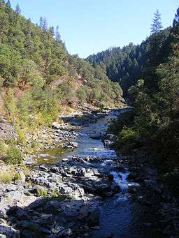
View of South Yuba from N Bloomfield Road Nevada City, CA
Country United States
State California
Region Upper Yuba Watershed
Source Lake Angela [1]
 - location Tahoe National Forest
Mouth Englebright Lake
 - location Yuba River
Length 65 mi (105 km), east-west
Basin 340 sq mi (881 km2)
Discharge for near Jones Bar
 - average 454 cu ft/s (13 m3/s)
 - max 53,600 cu ft/s (1,518 m3/s)
 - min 1 cu ft/s (0 m3/s)
Namesakes: South Yuba River State Park
South Yuba River Citizens League[2]
High water in the South Yuba River at the old CA-49 bridge, 8 January 2017

The 65.0-mile-long (104.6 km) [3] South Yuba River is a left-entering tributary of the Yuba River originating in the northern Sierra Nevada at Lake Angela in Nevada County about three quarters of a mile north of Donner Pass, about three miles east of the town of Soda Springs. After passing through Lake Van Norden with Upper Castle Creek (longer than the Lake Angela stem) entering from the right, it gathers numerous snow-fed tributaries running west through a marshy, lake-filled valley, criss-crossing Interstate 80. The river briefly enters Placer County, then flows into Lake Spaulding, then plunges westward into a steep-sided valley. Canyon Creek enters from the right, then Poorman Creek also from the right near the town of Washington. The river continues west into the foothills, crossing under State Route 49. Its mouth is on the east shore of upper Englebright Lake, formed by a dam across the Yuba River.[4]

Recreation

The river begins within the Tahoe National Forest. Parks along or near the South Yuba River include:

Course

South Yuba River course
This list is incomplete; you can help by expanding it.
description coordinates
source, Lake Angela dam 39°19′20″N 120°19′37″W / 39.3221273°N 120.3268679°W / 39.3221273; -120.3268679[1]
road, I-80 WB
dam, Lake Van Norden
road, I-80 EB
confluence, Lower Castle Creek
road, I-80 WB
road, Hampshire Rocks
road, I-80 EB
confluence, Rattlesnake Creek
road, I-80 WB
dam, Lake Spaulding
confluence, Jordan Creek
confluence, Rucker Creek 39°20′40″N 120°40′46″W / 39.344374°N 120.679491°W / 39.344374; -120.679491
confluence, Clear Creek 39°21′12″N 120°41′58″W / 39.353467°N 120.699527°W / 39.353467; -120.699527
confluence, Diamond Creek 39°21′19″N 120°44′26″W / 39.355159°N 120.740441°W / 39.355159; -120.740441
confluence, Canyon Creek 39°21′39″N 120°45′01″W / 39.360867°N 120.750156°W / 39.360867; -120.750156
confluence, Scotchman Creek 39°21′24″N 120°46′59″W / 39.356644°N 120.783104°W / 39.356644; -120.783104
road, Washington 39°21′38″N 120°47′41″W / 39.360493°N 120.794766°W / 39.360493; -120.794766
confluence, Poorman Creek 39°21′10″N 120°48′37″W / 39.352834°N 120.810291°W / 39.352834; -120.810291
confluence, McKilligan Creek 39°21′08″N 120°49′07″W / 39.352193°N 120.818654°W / 39.352193; -120.818654
border, Tahoe National Forest 39°20′15″N 120°54′31″W / 39.337451°N 120.908704°W / 39.337451; -120.908704
confluence, Humbug Creek 39°20′17″N 120°55′55″W / 39.338115°N 120.931932°W / 39.338115; -120.931932
border, Malakoff Diggins State Historic Park 39°20′15″N 120°54′33″W / 39.337384°N 120.90909°W / 39.337384; -120.90909
road, N Bloomfield (Edwards Crossing) 39°19′49″N 120°59′03″W / 39.3301664°N 120.984215°W / 39.3301664; -120.984215
border, Malakoff Diggins SHP
border, South Yuba River SP[5]
39°19′48″N 120°59′07″W / 39.330015°N 120.985351°W / 39.330015; -120.985351
confluence, Spring Creek 39°19′56″N 120°59′22″W / 39.332148°N 120.989408°W / 39.332148; -120.989408
road, Purdon (Purdon Crossing) 39°19′40″N 121°02′47″W / 39.327791°N 121.046505°W / 39.327791; -121.046505
confluence, Rock Creek 39°18′42″N 121°02′58″W / 39.311770°N 121.049323°W / 39.311770; -121.049323
former diversion, Excelsior Ditch 39°18′40″N 121°03′42″W / 39.311070°N 121.061631°W / 39.311070; -121.061631
road, CA 49 (bridge image)
confluence, Rush Creek 39°17′32″N 121°06′17″W / 39.292248°N 121.104803°W / 39.292248; -121.104803
confluence, Owl Creek
confluence, French Corral Creek
road, Pleasant Valley 39°17′34″N 121°11′37″W / 39.29286°N 121.193576°W / 39.29286; -121.193576
border, South Yuba River SP[5]
road, Bridgeport Covered Bridge
39°17′34″N 121°11′42″W / 39.292739°N 121.194906°W / 39.292739; -121.194906
mouth, Englebright Lake

See also

References

  1. 1 2 U.S. Geological Survey Geographic Names Information System: South Yuba River Note: the GNIS mouth coordinates plot at the Lake Angela dam
  2. "Motion to Intervene" (pdf). Friends of the River, Sierra Club, & South Yuba River Citizens League. October 17, 2005. Retrieved 2010-09-29.
  3. U.S. Geological Survey. National Hydrography Dataset high-resolution flowline data. The National Map, accessed March 10, 2011
  4. USGS Topo Maps for United States (Map). Cartography by United States Geological Survey. ACME Mapper. Retrieved 2010-08-23.
  5. 1 2 "South Yuba River SP". California State Parks. Parks.CA.gov. Retrieved 2010-09-30.
This article is issued from Wikipedia. The text is licensed under Creative Commons - Attribution - Sharealike. Additional terms may apply for the media files.