South Street (Philadelphia)
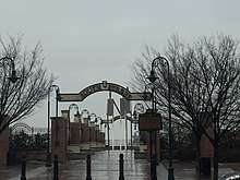 South Street eastern terminus at Penn's Landing | |
| Location | Philadelphia |
|---|---|
| West end | 33rd Street / Spruce Street in University City |
| Major junctions |
|
| East end | Front Street in Center City |
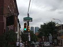
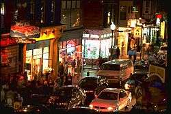
South Street is a street in Philadelphia, which was originally named "Cedar Street" in William Penn's original street grid,[1] it is an east-west street forming the southern border of Center City[2] and the northern border for South Philadelphia.[3] The stretch of South Street between Front Street and Seventh Street is known for its "bohemian", "punk", and generally "alternative" atmosphere and its diverse urban mix of shops, bars, and eateries. It is one of Philadelphia's largest tourist attractions.[4]
Layout
From west to east, South Street traverses the following neighborhoods:
- University City (West Philadelphia)
- Schuylkill
- Grays Ferry
- Fitler Square
- Rittenhouse Square
- Avenue of the Arts
- South Street Headhouse District
- Society Hill
South Street begins at 33rd and Spruce Streets in University City, heading east-southeast past the University of Pennsylvania's Franklin Field and the University Museum. It crosses the Schuylkill River on the South Street Bridge, a fixed bridge built in 2010 to replace a former double bascule bridge dating from 1923.[5] South Street then heads east (relative to the city grid), and becomes one-way eastbound from 27th Street all the way to Front Street.
South Street marks the 600 South block (from Market Street) in the city's gridiron street system. In West Philadelphia, the 600 South is delineated between 45th and 63rd Streets by Cedar Avenue, the name being a relic of the original name for South Street (Cedar Street) in the original plan for Philadelphia as drafted by William Penn. South Street and Cedar Avenue are discontinuous with each other due to Woodland Cemetery, the University of Pennsylvania (the former Blockley Township), and the Schuylkill River.
History
Named Cedar Street in William Penn's plan of Philadelphia, South Street was the traditional southern boundary of Philadelphia's city limits before the city annexed the townships of Passyunk, Moyamensing and Southwark.
Until the 1950s, South Street was known mainly as a garment district, with stores for men's suits and other clothing, while the more western areas around South Street served as a cultural and commercial center for South Philadelphia's African American community.[6] Real estate values plummeted after city planner Edmund Bacon and others proposed the Crosstown Expressway, a short limited-access expressway connecting the Schuylkill Expressway and I-95 that would have required the demolition of many buildings on South Street and Bainbridge Street (an east-west street one block south of South Street). The suddenly cheap property attracted artists and counterculture-types. The proposed expressway was never built due to public opposition.[7]
Public transportation
South Street is traversed over its entire length by SEPTA's Route 40 bus, running eastbound on South and westbound on Lombard Street through Center City. During evenings and weekends, the 40 bus avoids the pedestrian congestion east of Broad Street by turning north on Broad and then turning east on Pine Street all the way to Front Street.[8] Several other transit routes cross South Street, most important being the subsurface Broad Street Line with its station at Lombard-South.
See also
References
- ↑ Woodall, Peter (2013-01-16). "What's In An Odonym?". Hidden City Philadelphia. Retrieved 2017-11-03.
- ↑ Philadelphia Neighborhoods A-K. City of Philadelphia Department of Records.
- ↑ Philadelphia Neighborhoods Q-Z. City of Philadelphia Department of Records.
- ↑ What's In The South Street Neighborhood? (archived), Visitphilly.com Accessed August 15, 2012
- ↑ "South Street Bridge". Bridgehunter.com. Retrieved December 6, 2011.
- ↑ Hunter, Marcus Anthony (2013). Black Citymakers: How The Philadelphia Negro Changed Urban America. OUP USA.
- ↑ Ray, Matthew. "City and State honor Edmund Bacon". Weekly Press (originally published in). The Ed Bacon Foundation. Retrieved December 6, 2011.
- ↑ "SEPTA Route 40" (PDF). Retrieved December 6, 2011.
External links
| Wikimedia Commons has media related to South Street (Philadelphia). |
Coordinates: 39°56′30″N 75°09′02″W / 39.941758°N 75.15069°W