South Portsmouth, Kentucky
| South Portsmouth, Kentucky | |
|---|---|
| Unincorporated community | |
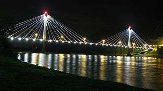 The U.S. Grant Bridge between Portsmouth and South Portsmouth | |
 South Portsmouth  South Portsmouth | |
| Coordinates: 38°43′28″N 83°00′48″W / 38.72444°N 83.01333°WCoordinates: 38°43′28″N 83°00′48″W / 38.72444°N 83.01333°W | |
| Country | United States |
| State | Kentucky |
| County | Greenup |
| Elevation | 554 ft (169 m) |
| Time zone | UTC-5 (Eastern (EST)) |
| • Summer (DST) | UTC-4 (EDT) |
| Area code(s) | 606 |
| GNIS feature ID | 503970[1] |
South Portsmouth is an unincorporated community in Greenup County, Kentucky, United States. South Portsmouth is located on the Ohio River across from Portsmouth, Ohio and 3 miles (4.8 km) west of South Shore, Kentucky. Kentucky Route 8 passes through the community.[2]
South Portsmouth was originally called Springville (or Springsville) due to the numerous springs in the area. Springville was incorporated as a town on March 3, 1876. The Chesapeake and Ohio Railroad built a track through the community in the early 1900s. Subsequently the name of the community was changed to South Portsmouth, presumably to indicate its location and strengthen its connection with Portsmouth, Ohio, a city of more than 20,000 people.[3]
References
- ↑ "South Portsmouth". Geographic Names Information System. United States Geological Survey.
- ↑ State Primary Road System: Greenup County (PDF) (Map). Kentucky Transportation Cabinet. 2013. Retrieved April 30, 2013.
- ↑ , Scholar Works, Morehead State University
Municipalities and communities of Greenup County, Kentucky, United States | ||
|---|---|---|
| Cities | 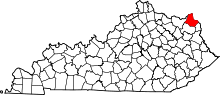 | |
| Unincorporated communities | ||
This article is issued from
Wikipedia.
The text is licensed under Creative Commons - Attribution - Sharealike.
Additional terms may apply for the media files.