South Patrick Shores, Florida
| South Patrick Shores, Florida | |
|---|---|
| CDP | |
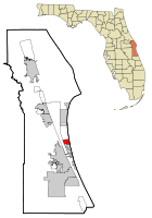 Location in Brevard County and the state of Florida | |
| Coordinates: 28°12′9″N 80°36′14″W / 28.20250°N 80.60389°WCoordinates: 28°12′9″N 80°36′14″W / 28.20250°N 80.60389°W | |
| Country |
|
| State |
|
| County | Brevard |
| Area | |
| • Total | 2.9 sq mi (7.4 km2) |
| • Land | 1.4 sq mi (3.7 km2) |
| • Water | 1.4 sq mi (3.6 km2) |
| Elevation | 13 ft (4 m) |
| Population (2010) | |
| • Total | 5,875 |
| • Density | 2,100/sq mi (790/km2) |
| Time zone | UTC-5 (Eastern (EST)) |
| • Summer (DST) | UTC-4 (EDT) |
| FIPS code | 12-67725[1] |
| GNIS feature ID | 1867209[2] |
South Patrick Shores is a census-designated place (CDP) in Brevard County, Florida, United States. The population was 5,875 at the 2010 census.[3] It is part of the Palm Bay–Melbourne–Titusville Metropolitan Statistical Area.
Geography
South Patrick Shores is located at 28°12′9″N 80°36′14″W / 28.20250°N 80.60389°W (28.202390, -80.604025).[4]
According to the United States Census Bureau, the CDP has a total area of 2.9 square miles (7.4 km2), of which 1.4 square miles (3.7 km2) is land and 1.4 square miles (3.6 km2), or 49.34%, is water.[5]
Surrounding areas
Demographics
As of the census[1] of 2000, there were 8,913 people, 3,563 households, and 2,668 families residing in the CDP. The population density was 4,331.3 people per square mile (1,670.5/km²). There were 4,197 housing units at an average density of 2,039.5/sq mi (786.6/km²). The racial makeup of the CDP was 90.44% White, 3.65% African American, 0.53% Native American, 2.09% Asian, 0.06% Pacific Islander, 0.93% from other races, and 2.31% from two or more races. Hispanic or Latino of any race were 4.97% of the population.
There were 3,563 households out of which 31.7% had children under the age of 18 living with them, 63.9% were married couples living together, 7.8% had a female householder with no husband present, and 25.1% were non-families. 20.9% of all households were made up of individuals and 11.1% had someone living alone who was 65 years of age or older. The average household size was 2.50 and the average family size was 2.89.
In the CDP, the population was spread out with 24.0% under the age of 18, 5.3% from 18 to 24, 29.0% from 25 to 44, 22.3% from 45 to 64, and 19.4% who were 65 years of age or older. The median age was 40 years. For every 100 females, there were 97.8 males. For every 100 females age 18 and over, there were 93.9 males.
The median income for a household in the CDP was $48,197, and the median income for a family was $53,231. Males had a median income of $36,358 versus $26,535 for females. The per capita income for the CDP was $22,904. About 3.8% of families and 4.6% of the population were below the poverty line, including 7.7% of those under age 18 and 2.2% of those age 65 or over.
Infrastructure
Roads
Travelocity.com named route A1A as the "Best Driving Route" in Florida. This runs close to the ocean. A secondary major route, paralleling it, is South Patrick Drive, which is close to the Banana River.
The Florida Department of Transportation maintains 513, and A1A.
See State Roads in Florida for explanation of numbering system.
References
- 1 2 "American FactFinder". United States Census Bureau. Retrieved 2008-01-31.
- ↑ "US Board on Geographic Names". United States Geological Survey. 2007-10-25. Retrieved 2008-01-31.
- ↑ "Profile of General Population and Housing Characteristics: 2010 Demographic Profile Data (DP-1): South Patrick Shores CDP, Florida". U.S. Census Bureau, American Factfinder. Retrieved January 31, 2012.
- ↑ "US Gazetteer files: 2010, 2000, and 1990". United States Census Bureau. 2011-02-12. Retrieved 2011-04-23.
- ↑ "Geographic Identifiers: 2010 Demographic Profile Data (G001): South Patrick Shores CDP, Florida". U.S. Census Bureau, American Factfinder. Retrieved January 31, 2012.
- ↑ Miramar means "View of the Sea" in Spanish
| Wikimedia Commons has media related to South Patrick Shores, Florida. |
Municipalities and communities of Brevard County, Florida, United States | ||
|---|---|---|
| Cities | 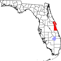 | |
| Towns | ||
| CDPs | ||
| Unincorporated communities | ||