South Jutland County
| South Jutland County Sønderjyllands Amt | ||
|---|---|---|
| Amt | ||
| ||
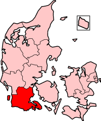 South Jutland County in Denmark | ||
| Established | 1 April 1970 | |
| Abolished | 1 January 2007 | |
| County seat | Aabenraa | |
| Municipalities | ||
| Area | ||
| • Total | 3,938 km2 (1,520 sq mi) | |
| Population (2006) | ||
| • Total | 252,433 | |
| • Density | 64/km2 (170/sq mi) | |
| Time zone | UTC+1 (CET) | |
| • Summer (DST) | UTC+2 (CEST) | |
| IM amt | 1050 | |
| ISO 3166 code | 3166-1[1] | |
| Successor | Region of Southern Denmark | |
South Jutland County (Danish: Sønderjyllands Amt) is a former county (Danish: amt) on the south-central portion of the Jutland Peninsula in southern Denmark.
The county was formed on 1 April, 1970, comprising the former counties of Aabenraa (E), Haderslev (N), Sønderborg (SE), and Tønder (SW). The county was abolished effective 1 January, 2007, when the Region of Southern Denmark was formed.
Following the reunification of the region with Denmark, the Church of Denmark elevated Haderslev to a diocese in 1923[2] and divided the region between the dioceses of Ribe (W) and Haderslev (E). This arrangement remains in effect.
Short description of South Jutland
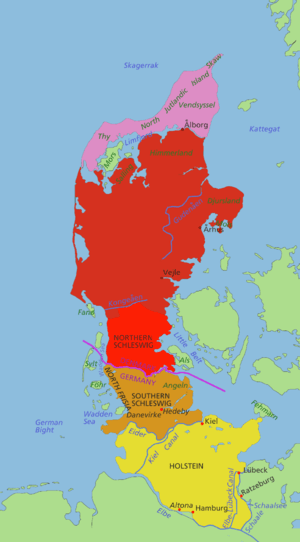
South Jutland county is also known as Northern Schleswig (Danish: Nordslesvig, German: Nordschleswig). The name refers specifically to the southernmost 50 kilometers of the Danish part of the Jutland Peninsula that formerly belonged to the former Duchy of Schleswig (Danish: Slesvig or Sønderjylland); a Danish fief under the Kings of Denmark.
Denmark lost the Duchy of Schleswig, as well as the German Duchies of Holstein and Lauenburg, to Prussia and Austria in 1864 in the Second War of Schleswig. Following Austria's defeat in the Austro-Prussian War (1866), all three provinces were annexed to Prussia. Following the defeat of Germany in World War I, the Allied powers organised two plebiscites in Northern and Central Schleswig on 10 February and 14 March 1920, respectively. In Northern Schleswig 75% voted for reunification with Denmark and 25% for staying with Germany. In Central Schleswig the situation was reversed with 80% voting for Germany and 20% for Denmark. No vote ever took place in the southern third of Schleswig, as the result was a foregone conclusion. On 15 June 1920, Northern Schleswig was officially reunited with Denmark. It is the only one of the German transfers of territory after World War I that the Nazis did not dispute.
Central Schleswig chose to remain with Southern Schleswig as part of Germany and is today a part of the German state of Schleswig-Holstein.
A small ethnic German minority still lives in South Jutland county - predominantly in and near the towns of Tønder and Aabenraa (German: Tondern and Apenrade).
Important settlements: Sønderborg (27,000), Aabenraa (15,000), Haderslev (21,000 people) and Tønder (8,000).[3]
1970 Borders
As reconstituted in 1970, South Jutland County had slightly different borders to the area gained from Germany in 1920: the towns of Hejle, Taps and Vejstrup (which were Danish throughout the period 1864 to 1920) were included in its jurisdiction, whereas Spandet, Roager and Hviding (German from 1864-1920) were included in the neighbouring 1970-2006 county of Ribe.[4]
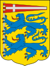
Insignia
The coat of arms of South Jutland County was designed in 1980 and is derived from the historic coat of arms of Schleswig which in turn is derived from the national coat of arms of Denmark. The inspiration for the Dannebrog pennant was a 13th-century seal used by Erik Abelsøn, Duke of Schleswig.
List of County Mayors
| From | To | County Mayor |
|---|---|---|
| 1 April, 1970 | 2 December, 1981 | Erik Jessen (Venstre) |
| 2 December, 1981 | 1 July, 2000 | Kresten Philipsen (Venstre) |
| 1 July, 2000 | 31 December, 2006 | Carl Holst (Venstre) |
Municipalities (1970-2006)
- Aabenraa municipality
- Augustenborg municipality
- Bredebro municipality
- Broager municipality
- Bov municipality
- Christiansfeld municipality
- Gram municipality
- Gråsten municipality
- Haderslev municipality
- Højer municipality
- Lundtoft municipality
- Løgumkloster municipality
- Nordborg municipality
- Nørre-Rangstrup municipality
- Rødding municipality
- Rødekro municipality
- Skærbæk municipality
- Sundeved municipality
- Sønderborg municipality
- Sydals municipality
- Tinglev municipality
- Tønder municipality
- Vojens municipality
References
- ↑ "Sønderjyllands Amt". digdag.dk (in Danish). Retrieved 2 April 2018.
- ↑ Biskopper over Haderslev Stift Archived 2007-03-12 at the Wayback Machine.
- ↑ http://www.statistikbanken.dk/statbank5a/SelectVarVal/Define.asp?Maintable=BEF44&PLanguage=1
- ↑ http://www.zonu.com/fullsize/2011-06-10-13931/Schleswig-Holstein-1897.html Map of Schleswig from 1897
| Amter | ||
|---|---|---|
| Municipalities (kommuner) with county privileges | ||
1 Local county abolished in 2003. | ||