South Hams District Council
| South Hams District Council | |
|---|---|
|
Logo | |
| Type | |
| Type | |
| Houses | Unicameral |
| History | |
| Founded | 1 April 1974 |
| Leadership | |
Leader of the Council | |
| Structure | |
| Seats | 31 |
|
24 / 31 | |
|
3 / 31 | |
|
3 / 31 | |
|
1 / 31 | |
| Elections | |
| First past the post | |
Last election | 7 May 2015 |
Next election | May 2019 |
| Meeting place | |
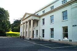 | |
| Follaton House, Totnes | |
| Website | |
| www.southhams.gov.uk | |
South Hams District Council is the council administering the non-metropolitan district of the South Hams in Devon, England. It was formed in 1974 and covers a population of around 85,000. The District Council is part of a three-tier government with Devon County Council above and town and parish councils below. It elects 31 councillors every four years and has historically been represented by the Conservative Party.
History
The council's administrative area was formed on 1 April 1974 from the merge of existing areas in Devon due to the Local Government Act 1972. This included the boroughs of Clifton Dartmouth Hardness and Totnes; the urban districts of Kingsbridge and Salcombe; and the rural districts of Kingsbridge, Plympton St. Mary and Totnes.[2]
Politics
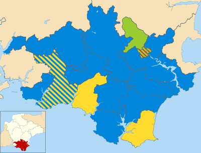
In South Hams, most councillors who are elected have been nominated by one of England's major political parties, although there have also been a small number of independents in previous elections. As of the 7 May 2015 election, the majority of councillors in the council are Conservatives, who hold 25 of the 31 seats.[3] Up until 1983, the council was governed by independent councillors, before the Conservatives gained a majority in 1987; a position which has since been held (excluding a brief period where they lost control between 1995–99).[4]
| Date | Conservative | +/- | Greens | +/- | Liberal Democrat | +/- | Labour | +/- | Independent | +/- | Control | |||||
| 2011 | 30 | 3 | 5 | 1 | 1 | Conservative | ||||||||||
| 2015[note 1][6] | 25 | -5 | 3 | = | 2 | -3 | 1 | = | 0 | -1 | Conservative | |||||
| 2017 | 24 | -1 | 3 | = | 3 | +1 | 1 | = | 0 | = | Conservative | |||||
Responsibilities for services
As of mid-2017 est., South Hams District Council is responsible for a population of 85,300 (ranked 287th in England) and covers an area of 886.5 km2 (342.3 sq mi) (ranked 39th).[7][8] South Hams along with Devon County Council and 61 town and parish councils operate a three-tier system of local government. Devon County Council is responsible for larger issues such as education, highways and social services. South Hams District Council and Devon CC are jointly responsible for community transport, economic development, emergency planning, environmental protection, museums and arts, recycling, street lighting and tourism. More minor responsibilities are held by just the district council and/or the town and parish councils. Some of these responsibilities include car parks, litter, public toilets and waste collection.[9] In order to reduce waste and injuries to the public, the council offer seagull-proof sacks as form of waste management.[10]
Notes
References
- ↑ "Cllr R J Tucker". South Hams District Council. Retrieved 13 December 2015.
- ↑

- ↑ "Declaration of Result of Poll". South Hams District Council. 7 May 2015. Retrieved 27 October 2015.
- ↑ "South Hams". BBC News Online. Retrieved 20 November 2009.
- ↑ http://www.legislation.gov.uk/uksi/2014/3059/made
- ↑ "Declaration of Result of Poll". South Hams District Council. 7 May 2015. Retrieved 27 October 2015.
- ↑ "Population Estimates for UK, England and Wales, Scotland and Northern Ireland, Mid-2017". Office for National Statistics. 28 June 2018. Retrieved 28 June 2018.
- ↑ "Standard Area Measurements (2016) for Administrative Areas in the United Kingdom". Office for National Statistics. 1 February 2017. Retrieved 9 February 2017.
- ↑ "Local authorities - who does what ?". Devon County Council. Retrieved 2 January 2016.
- ↑ "Free Seagull Sacks". South Hams District Council. Retrieved 2 January 2016.