South Dakota Highway 38
| ||||
|---|---|---|---|---|
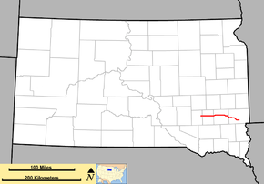 Route of SD 38 (in red) | ||||
| Route information | ||||
| Defined by SDCL §31-4-159 | ||||
| Maintained by SDDOT | ||||
| Length | 63.393 mi[1] (102.021 km) | |||
| Major junctions | ||||
| West end |
| |||
|
| ||||
| East end |
| |||
| Location | ||||
| Counties | Davison, Hanson, McCook, Minnehaha | |||
| Highway system | ||||
| ||||

South Dakota Highway 38 (SD 38) is a state highway in the state of South Dakota. The highway runs from Mitchell to Sioux Falls.
Route description
SD 38 begins at an intersection with a business loop of I-90 (Burr Street) along Havens Street in Mitchell. It runs east and leaves the city of Mitchell, then crosses the James River. As it crosses the river, the highway leaves Davison County and enters Hanson County. The route continues east, roughly paralleling I-90 to the north. It passes south of Fulton and then intersects SD 25. SD 38 then curves slightly to the north and enters McCook County. Later, it passes through Salem and intersects U.S. Route 81 (US 81). East of Salem, the highway curves to the southeast and passes through the southeastern corner of the city of Montrose. The route then bends further to the southeast and enters Minnehaha County.[2]
About two miles (3.2 km) east of the county line, SD 38 turns to the east and intersects SD 19. The two routes run together through the northern part of Humboldt, where SD 19 splits off to the north and SD 38 continues east toward Hartford. Once it reaches Hartford, the highway bends to the southeast. Southeast of the city, SD 38 shares a folded diamond interchange with I-90. After this interchange, SD 38 curves to the east and enters Sioux Falls. About one mile (1.6 km) farther east, SD 38 meets its eastern terminus at another folded diamond interchange with I-29.[2]
Major intersections
| County | Location | mi[1] | km | Destinations | Notes |
|---|---|---|---|---|---|
| Davison | Mitchell | 0.000 | 0.000 | Western end | |
| Hanson | | 3.550 | 5.713 | ||
| Farmer | 17.646 | 28.398 | |||
| McCook | Salem | 31.940 | 51.402 | ||
| Minnehaha | Humboldt | 48.563 | 78.155 | Western end of SD 19 overlap | |
| 49.609 | 79.838 | Eastern end of SD 19 overlap | |||
| Buffalo Ridge | 59.078 | 95.077 | I-90 exit 390 | ||
| Sioux Falls | 64.393 | 103.630 | I-29 exit 83; eastern end | ||
1.000 mi = 1.609 km; 1.000 km = 0.621 mi
| |||||
References
Route map:
- 1 2 "State Highway Log" (PDF). Mitchell region: South Dakota Department of Transportation. January 2011. pp. 92–98. Retrieved December 23, 2011.
- 1 2 Google (December 23, 2013). "South Dakota Highway 38" (Map). Google Maps. Google. Retrieved December 23, 2013.