South Dakota Highway 158
| ||||
|---|---|---|---|---|
 | ||||
| Route information | ||||
| Defined by SDCL §31-4-200 | ||||
| Maintained by SDDOT | ||||
| Length | 9.150 mi[1] (14.725 km) | |||
| Major junctions | ||||
| West end |
| |||
| East end |
| |||
| Location | ||||
| Counties | Grant | |||
| Highway system | ||||
| ||||

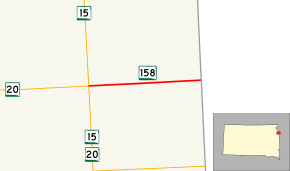
South Dakota Highway 158 (SD 158) is a 9.150-mile-long (14.725 km) state highway in the east-central part of the U.S. state of South Dakota. The entire highway is located in Grant County. It travels from an intersection with SD 15 and SD 20 to the Minnesota state line, where it continues as County Road 44 (CR 44). The road is maintained by the South Dakota Department of Transportation (SDDOT), and is not part of the National Highway System.
Route description
SD 158 begins at an intersection with SD 15 and SD 20 north of La Bolt and treks east through flat farmland. The highway continues east for approximately nine miles (14 km) before curving to the northeast and ending at the Minnesota state line.[2][3]
SD 158 is maintained by SDDOT. In 2012, the traffic on the highway was measured in average annual daily traffic, and SD 158 had an average of 235 vehicles.[1] The designation is not a part of the National Highway System,[4] a system of highways important to the nation's defense, economy, and mobility.[5]
Major intersections
The entire route is in Vernon Township, Grant County.
| mi[1] | km | Destinations | Notes | ||
|---|---|---|---|---|---|
| 0.000 | 0.000 | ||||
| 9.150 | 14.725 | Continuation into Minnesota | |||
| 1.000 mi = 1.609 km; 1.000 km = 0.621 mi | |||||
References
- 1 2 3 "State Highway Log" (PDF). South Dakota Department of Transportation. January 2012. Retrieved March 3, 2013.
- ↑ Google (March 3, 2013). "South Dakota Highway 158" (Map). Google Maps. Google. Retrieved March 3, 2013.
- ↑ South Dakota Atlas & Gazetteer. Yarmouth, ME: DeLorme. 2009. p. 35. ISBN 0-89933-330-3.
- ↑ National Highway System: South Dakota (PDF) (Map). Federal Highway Administration. October 1, 2012. Retrieved March 3, 2013.
- ↑ Natzke, Stefan; Neathery, Mike; Adderly, Kevin (September 26, 2012). "What is the National Highway System?". National Highway System. Federal Highway Administration. Retrieved March 3, 2013.
External links
Route map: