South Carolina Highway 99
| ||||
|---|---|---|---|---|
 | ||||
| Route information | ||||
| Maintained by SCDOT | ||||
| Length | 9.22 mi[1] (14.84 km) | |||
| Major junctions | ||||
| South end |
| |||
|
| ||||
| North end |
| |||
| Location | ||||
| Counties | Chester | |||
| Highway system | ||||
| ||||

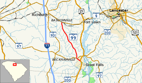
South Carolina Highway 99 (SC 99) is a 9-mile-long (14 km) state highway in the U.S. state of South Carolina. The highway connects Great Falls with rural areas of Chester County.
Route description
SC 99 begins at an intersection with U.S. Route 21 (US 21) and SC 200 (Pendergrass Boulevard) in Great Falls within Chester County. It travels to the northwest. On the edge of the city limits of the town is an intersection with SC 97 (Francis Avenue). They have a very brief concurrency. SC 99 travels in a north-northwesterly direction and passes Howze Cemetery. The highway continues traveling through rural areas and meets its northern terminus, an intersection with SC 9 (Lancaster Highway).[2]
Major intersections
The entire route is in Chester County.
| Location | mi[1] | km | Destinations | Notes | |
|---|---|---|---|---|---|
| Great Falls | 0.00 | 0.00 | |||
| 0.89 | 1.43 | Southern end of SC 97 concurrency | |||
| | 0.93 | 1.50 | Northern end of SC 97 concurrency | ||
| | 9.22 | 14.84 | |||
1.000 mi = 1.609 km; 1.000 km = 0.621 mi
| |||||
See also


References
- 1 2 "Statewide Highways (shapefile)" (zip). South Carolina Department of Transportation. September 29, 2017. Retrieved December 8, 2017.
- ↑ Google (May 4, 2018). "South Carolina Highway 99" (Map). Google Maps. Google. Retrieved May 4, 2018.
External links

- SC 99 South Carolina Hwy Index
This article is issued from
Wikipedia.
The text is licensed under Creative Commons - Attribution - Sharealike.
Additional terms may apply for the media files.