South Carolina Highway 311
| ||||
|---|---|---|---|---|
 | ||||
| Route information | ||||
| Maintained by SCDOT | ||||
| Length | 9.25 mi[1] (14.89 km) | |||
| Major junctions | ||||
| West end |
| |||
| East end |
| |||
| Location | ||||
| Counties | Berkeley | |||
| Highway system | ||||
| ||||

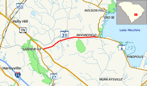
South Carolina Highway 311 (SC 311) is a 9.3-mile-long (15.0 km) state highway in the southeastern part of the U.S. state of South Carolina. The highway travels in a west-east orientation from a point approximately six miles (9.7 km) southeast of Holly Hill to a point approximately four miles (6.4 km) south of Cross.
Route description
SC 311 begins at an intersection with U.S. Route 176 (US 176) southwest of Holly Hill. The route heads northeast, and then east to its eastern terminus, an intersection with SC 6, south of Cross.[2]
SC 311 is not part of the National Highway System, a system of roadways important to the nation's economy, defense, and mobility.[3]
Major intersections
The entire route is in Berkeley County.
| Location | mi[1] | km | Destinations | Notes | |
|---|---|---|---|---|---|
| | 0.00 | 0.00 | |||
| | 9.25 | 14.89 | |||
| 1.000 mi = 1.609 km; 1.000 km = 0.621 mi | |||||
See also


References
- 1 2 South Carolina Department of Transportation: Statewide Highways 2012. Specifics: . Files: .
- ↑ Google (February 2, 2013). "Route of SC 311" (Map). Google Maps. Google. Retrieved February 2, 2013.
- ↑ "National Highway System: South Carolina" (PDF). United States Department of Transportation. October 1, 2012. Retrieved July 1, 2013.
External links
Route map:

This article is issued from
Wikipedia.
The text is licensed under Creative Commons - Attribution - Sharealike.
Additional terms may apply for the media files.