South Carolina Highway 291
| ||||
|---|---|---|---|---|
| Pleasantburg Drive | ||||
 | ||||
| Route information | ||||
| Maintained by SCDOT | ||||
| Length | 11.40 mi[1] (18.35 km) | |||
| Existed | 1941 – present | |||
| Major junctions | ||||
| South end |
| |||
| North end |
| |||
| Location | ||||
| Counties | Greenville | |||
| Highway system | ||||
| ||||

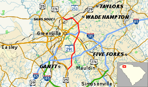
South Carolina Highway 291 (SC 291), locally known as Pleasantburg Drive, is a South Carolina state highway that runs as a major commercial artery for the eastern sections of Greenville, South Carolina in Greenville County, South Carolina. This highway runs by Greenville Technical College, the Greenville Downtown Airport, and Bob Jones University.[2] The road south of U.S. Highway 276 (US 276), Laurens Road, is called South Pleasantburg Drive, while the road north of Laurens Road is called North Pleasantburg Drive.[2]
Route description
The road begins at US 25 at Augusta Road, heading north as South Pleasantburg Drive, a six lane road, passing by businesses before an intersection over Interstate 85 (I-85). The road continues east as a commercial road, through many business in Greenville, passing by Greenville Technical College's (Greenville Tech) Barton (or Main) Campus[3] and the former McAlister Square Shopping Center to the east of the road. At an interchange with US 276, the road becomes North Pleasantburg Drive, continuing north, passing the Greenville Downtown Airport and the Carolina First Center to the east via Tower Drive.[4][5] The road then passes over Interstate 385, continuing north through the North Hills Shopping Center, quickly followed by Bob Jones University to the west.[6] At the intersection with County Road 304, SC 291 turns west for one block before meeting with US 29 at Wade Hampton Boulevard, before turning northwest. It continues through more commercial development before making a turn west to South Carolina Highway 253 at Paris Mountain Road, then to its northern terminus at an intersection with US 25/US 276 at Poinsett Highway.[2][7]
History
The road was established in 1941.[2] From the 1960s to the 1980s, the Pleasantburg Drive or SC 291 area was the location for office and retail activity for the Greenville area.[4] This included the establishment of McAlister Square in 1968 which closed in the early 2000s and is part of the University Center of Greenville.[8] A revitalization plan for the Pleasantburg Drive area began in 1997 and a report was issued seven years later.[4]
Major intersections
The entire route is in Greenville, Greenville County.
| mi[1] | km | Destinations | Notes | ||
|---|---|---|---|---|---|
| 0.00 | 0.00 | ||||
| 2.10 | 3.38 | Exit 46B (I-85), missing movements via Augusta Road and Mauldin Road | |||
| 5.90 | 9.50 | Interchange | |||
| 6.94 | 11.17 | Exit 40A–B (I-385) | |||
| 8.52 | 13.71 | ||||
| 11.40 | 18.35 | ||||
| 1.000 mi = 1.609 km; 1.000 km = 0.621 mi | |||||
References
- 1 2 "STATEWIDE HIGHWAYS 2012". South Carolina Department of Transportation. 2012. Retrieved January 22, 2013.
- 1 2 3 4 Greenville, South Carolina city government flyer of Pleasantburg Drive. Archived 2010-06-14 at the Wayback Machine. - 2005 flyer accessed 28 June 2010.
- ↑ Location of Greenville Technical College's Barton (or Main) Campus in South Carolina. Archived 2010-05-27 at the Wayback Machine. - accessed 28 June 2010.
- 1 2 3 Greenville, South Carolina Pleasantburg Master Plan. Archived 2010-06-17 at the Wayback Machine. - May 2004 report released 28 June 2010.
- ↑ Location of Greenville Downtown Airport in Greenville, South Carolina. Archived 2010-05-09 at the Wayback Machine. - accessed 28 June 2010.
- ↑ Directions to Bob Jones University in Greenville, South Carolina. Archived 2010-05-27 at the Wayback Machine. - accessed 28 June 2010.
- ↑ Google (January 22, 2013). "South Carolina Highway 291" (Map). Google Maps. Google. Retrieved January 22, 2013.
- ↑ History of the University Center of Greenville. Archived 2010-07-01 at the Wayback Machine. - accessed 28 June 2010.
External links
Route map:
| Wikimedia Commons has media related to South Carolina Highway 291. |
- Angelfire.com listing of South Carolina Highways 290-99. - accessed 1 July 2010.