South Carolina Highway 212
| ||||
|---|---|---|---|---|
 | ||||
| Route information | ||||
| Maintained by SCDOT | ||||
| Length | 5.67 mi[1] (9.12 km) | |||
| Existed | 1938 – present | |||
| Major junctions | ||||
| South end |
| |||
| North end |
| |||
| Location | ||||
| Counties | Colleton | |||
| Highway system | ||||
| ||||

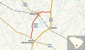
South Carolina Highway 212 (SC 212) is a primary state highway in the U.S. state of South Carolina. It serves the town of Williams by connecting it with nearby highways.
Route description
SC 212 is a two-lane rural highway that connects the town of Williams between SC 64 and U.S. Route 21 (US 21). Within Williams, it intersects SC 362 at its eastern terminus.[2]
History
Established around 1938 as a new primary routing as a spur from US 21 to Williams. In 1940, it was extended south to its current southern terminus at SC 64. In 1950, the entire route was completely paved.[3]
Junction list
The entire route is in Colleton County.
| Location | mi[1] | km | Destinations | Notes | |
|---|---|---|---|---|---|
| | 0.00 | 0.00 | |||
| Williams | 3.81 | 6.13 | Eastern terminus of SC 362 | ||
| | 5.67 | 9.12 | |||
| 1.000 mi = 1.609 km; 1.000 km = 0.621 mi | |||||
References
- 1 2 South Carolina Department of Transportation: Statewide Highways 2012. Specifics: . Files: .
- ↑ Google (September 7, 2013). "South Carolina Highway 212" (Map). Google Maps. Google. Retrieved September 7, 2013.
- ↑ General Highway Map, Colleton County, South Carolina (PDF) (Map). Cartography by SCDOT. South Carolina Department of Transportation. 1943. Retrieved September 10, 2013.
External links
Route map:

- Mapmikey's South Carolina Highways Page: SC 210-219
This article is issued from
Wikipedia.
The text is licensed under Creative Commons - Attribution - Sharealike.
Additional terms may apply for the media files.