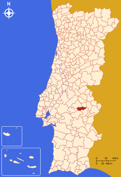
Sousel
| Sousel | |||
|---|---|---|---|
| Municipality | |||
| |||
 | |||
| Coordinates: 38°57′N 7°40′W / 38.950°N 7.667°WCoordinates: 38°57′N 7°40′W / 38.950°N 7.667°W | |||
| Country |
| ||
| Region | Alentejo | ||
| Subregion | Alentejo Central | ||
| Intermunic. comm. | Alto Alentejo | ||
| District | Portalegre | ||
| Parishes | 4 | ||
| Government | |||
| • President | Manuel Valério (PS) | ||
| Area | |||
| • Total | 279.32 km2 (107.85 sq mi) | ||
| Population (2011) | |||
| • Total | 5,074 | ||
| • Density | 18/km2 (47/sq mi) | ||
| Time zone | WET/WEST (UTC+0/+1) | ||
| Website | http://www.cm-sousel.pt | ||
.png)
Sousel (Portuguese pronunciation: [sowˈzɛɫ]) is a municipality in the District of Portalegre in Portugal. The population in 2011 was 5,074,[1] in an area of 279.32 km².[2]
The municipality is famous for its olive trees and as a great hunting region.
The Calça e Pina family was the main developer of Sousel in the 18th century. The economy is mainly based on agriculture, but tourism plays a major role in the region's economy as well.
The present Mayor is Manuel Valério, elected by the Social Party. The municipal holiday is Easter Monday.
Parishes
Administratively, the municipality is divided into 4 civil parishes (freguesias):[3]
- Cano
- Casa Branca
- Santo Amaro
- Sousel
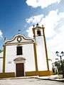 Local church.
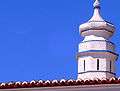 Distinctive Alentejano chimney.
References
- ↑ Instituto Nacional de Estatística
- ↑ Direção-Geral do Território Archived 2014-09-29 at Archive.is
- ↑ Diário da República. "Law nr. 11-A/2013, page 552 117" (pdf) (in Portuguese). Retrieved 31 July 2014.
External links
This article is issued from
Wikipedia.
The text is licensed under Creative Commons - Attribution - Sharealike.
Additional terms may apply for the media files.