Souleuvre Viaduct
| Souleuvre Viaduct | |
|---|---|
 Le viaduc de la Souleuvre | |
| Coordinates | 48°57′06″N 0°51′52″W / 48.95154°N 0.864475°WCoordinates: 48°57′06″N 0°51′52″W / 48.95154°N 0.864475°W |
| Carries | Caen to Saint-Lô and Vire line |
| Locale | La Ferrière-Harang, Normandy, France |
| Official name | Le viaduc de la Souleuvre |
| Characteristics | |
| Material | metallic |
| History | |
| Designer | Gustave Eiffel |
| Construction end | November 12, 1893 |
| Closed | 1960 |
Viaduc de la Souleuvre is a partially demolished railway viaduct over the Souleuvre River in La Ferrière-Harang, Normandy, France, now used as for bungee jumping. Coordinates: 48°57′3.72″N 00°51′50.29″W / 48.9510333°N 0.8639694°W
History
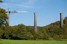
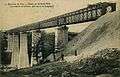
Built by French engineer Gustave Eiffel for the Caen to Saint-Lô and Vire line, the Viaduc de la Souleuvre opened November 12, 1893. The total length of the viaduct was 364.20 m (1,200 ft), with a maximum height of 62.50 m (210 ft) and was set on 5 stone pillars. The height of these pillars varies between 26 and 60 m, their base is 18m by 8m and their top 7m by 4m. They were built from granite blocks from the Vire region quarries, each of a weight of 350 kg, for a total of 14000 m³ and with mortar sand coming from the Chausey Islands.
Before World War II, about fifteen trains a day crossed the viaduct. It was used by the Germans during the War. The Allies tried to destroy the viaduct in 1944, but only managed to partially damage it. More than 500 bombs were dropped around it without hitting it. In August 1944, the viaduct was repaired by the Americans.
When the rail line closed in 1960 the viaduct went into disrepair. Despite large local preservationist opinion campaigns, the railway platform was dynamited in 1970. Only the five huge stone pillars remained.
Bungee jumping
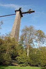
In 1990, a permanent platform for bungee jumping was established by A. J. Hackett atop the highest pillar. A light gangway was established where the railway platform used to be, allowing access to the platform from the side of the bridge.
Photo gallery
 Calvados viaduct at Souleuvre
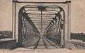 Entrance to the Calvados viaduct at Souleuvre
 Bungee jump from the Souleuvre Viaduct
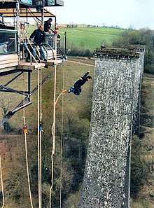 Bungee Jump from Viaduc de la Souleuvre