Sotunki
| Sotunki Sottungsby | |
|---|---|
| City District | |
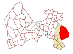 Location on the map of Vantaa | |
| Coordinates: 60°17′04″N 25°08′30″E / 60.28444°N 25.14167°ECoordinates: 60°17′04″N 25°08′30″E / 60.28444°N 25.14167°E | |
| Population (1.1.2014)[1] | |
| • Total | 641 |
| Time zone | GMT +2 |
| Postal Code(s) | 01200, 01260 |
| Website |
www |
Sotunki (Swedish: Sottungsby) is a district of the city of Vantaa, Finland. The district has an area of 13.7 square kilometers and a population of about 641 (as of 2014), making it one of the least densely populated and most rural districts in the city. It is served by its own high school. The valley and farmland in Sotunki are the district's main attractions. The area has been inhabited since the palaeolithic, with three different stone age camp sites identified.
References
- ↑ "Archived copy" (PDF). Archived from the original (PDF) on 2015-02-02. Retrieved 2015-05-01.
| Myyrmäki (Myrbacka) area |
|  |
|---|---|---|
| Kivistö area |
| |
| Aviapolis area |
| |
| Tikkurila (Dickursby) area |
| |
| Koivukylä (Björkby) area |
| |
| Korso area | ||
| Hakunila (Håkansböle) area |
| |
This article is issued from
Wikipedia.
The text is licensed under Creative Commons - Attribution - Sharealike.
Additional terms may apply for the media files.