Kivistö
| Kivistö | |
|---|---|
| City District | |
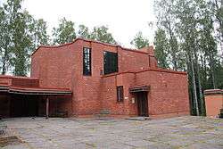 The main church of Kivistö | |
| Etymology: Finnish: kivi ("stone", referring to inarable granite bedrock) | |
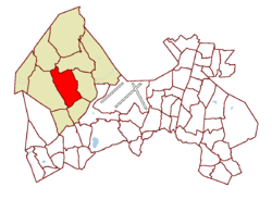 Location on the map of Vantaa, with the district in red and the major region in light brown | |
| Coordinates: 60°19′25″N 24°50′43″E / 60.32361°N 24.84528°ECoordinates: 60°19′25″N 24°50′43″E / 60.32361°N 24.84528°E | |
| Country |
|
| City |
|
| Major region | Kivistö |
| Area | |
| • Total | 7.0 km2 (2.7 sq mi) |
| • Major region | 71.5 km2 (27.6 sq mi) |
| Population (1.1.2014)[1] | |
| • Total | 3,452 |
| • Density | 490/km2 (1,300/sq mi) |
| • Major region | 8,560 |
| • Major region density | 120/km2 (310/sq mi) |
| Time zone | GMT +2 |
| Postal Code(s) | 01700 |
| Website |
vantaankivisto |
Kivistö is a district and major region of the municipality of Vantaa, Finland, located within the northwestern part of the city. The district has a population of 3,452 and a population density of 490 inhabitants per square kilometre (1,300/sq mi).[1]
The district is bordered to the west by Hämeenlinnanväylä (a constituent of the National road 3 (E12)), to the south by the district of Piispankylä, to the east by the district of Lapinkylä, and to the north by the districts of Seutula and Luhtaanmäki.
The Kivistö major region consists of ten districts: the central Kivistö, Lapinkylä, Kuninkaanmäki, Seutula, Piispankylä, Riipilä, Kiila, Vestra, Luhtaanmäki, and Myllymäki. As of January 2014, the Kivistö major region has a total population of 8,560 and a population density of 120 inhabitants per square kilometre (310/sq mi). The Kivistö major region is the least populated—and the least densely populated—major region in Vantaa.[1][2]
History
The earliest evidence of settlement in the area dates back to the early 16th century. The original inhabitants of the area are believed to have spoken Finnish, which was unique for the time. The name "Kivistö" was coined by them, and it is thought to be in reference to the inarable exposed granite bedrock common to the area. The existing farmland in Kivistö has been in use since the 17th century, during which time the Linna Manor was constructed there.[2]
The first of the contemporary housing in the area was built in the early 1950s. The land was primarily sold by the construction firm Omakiinteistö Oy, and settlers were unaware of a nearby radio station, which handled the Finnish government's international shortwave radio communications. Due to radio-frequency interference, the construction of electrical infrastructure in the area was banned, and the district spent its first years without electricity. After three years of complaints and protests, the ban was lifted, and Kivistö was permitted electrical power. Protests included the construction of a roadside sign leading into district that read: "Öljylamppukylä—jo 3 vuotta n. 200 taloa ilman sähköä" or "Oil Lamp Town—already 3 years of about 200 houses without electricity".[3]
Amenities
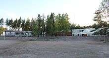
Kivistö has its two public schools, five day care businesses, and a nursing home specializing in dementia care.
In 2015, the Kivistö railway station was opened as a part of the Ring Rail Line. The rail connects Kivistö to downtown Helsinki, as well as Helsinki Airport and Tikkurila.
References
- 1 2 3 Vantaan väestö 2013/2014 (PDF) (Report). Vantaa: City of Vantaa, Tietopalveluyksikkö. 20 August 2014. p. 33. ISBN 978-952-443-480-5. Archived from the original (PDF) on 2 February 2015. Retrieved 4 July 2015.
- 1 2 Vantaa alueittain 2010: Kivistön suuralue (PDF) (Report). Vantaa: City of Vantaa, Tietopalveluyksikkö. 2010. p. 74-77. Archived from the original (PDF) on 2014-09-03. Retrieved 4 July 2015.
- ↑ http://www.valomerkki.fi/vantaan-lauri/vantaan-lauri-arkisto/marja-vantaan_tuleva_keskus%5Bpermanent+dead+link%5D
External links
| Wikimedia Commons has media related to Kivistö. |
| Myyrmäki (Myrbacka) area |
|  |
|---|---|---|
| Kivistö area |
| |
| Aviapolis area |
| |
| Tikkurila (Dickursby) area |
| |
| Koivukylä (Björkby) area |
| |
| Korso area | ||
| Hakunila (Håkansböle) area |
| |