Sonora Peak
| Sonora Peak | |
|---|---|
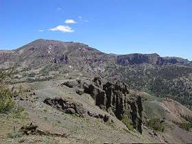 Sonora Peak from Sonora Pass | |
| Highest point | |
| Elevation | 11,464 ft (3,494 m) NAVD 88[1] |
| Prominence | 1,816 ft (554 m) [1] |
| Listing | California county high points 10th |
| Coordinates | 38°21′14″N 119°38′07″W / 38.3538016°N 119.6351721°WCoordinates: 38°21′14″N 119°38′07″W / 38.3538016°N 119.6351721°W [2] |
| Geography | |
| Location | Alpine and Mono counties, California, U.S. |
| Parent range | Central Sierra Nevada |
| Topo map | USGS Sonora Pass |
| Climbing | |
| Easiest route | Hike, class 1-2[3] |
Sonora Peak is a mountain located in the Central Sierra Nevada mountains of California north of Sonora Pass. Located on the boundary between Alpine and Mono counties, it is the highest point in Alpine County.[1] Due to the high elevation, most of the precipitation this mountain receives consists of snow.[4]
One of the most direct routes of ascent starts at Sonora Pass, 2 miles (3.2 km) south as the crow flies. Starting at the trailhead of the PCT on Sonora Pass, it is about a 2.5-mile (4.0 km) hike with 1,000 feet (300 m) elevation gain to the top of a pass. From there, the easiest and most direct way is to turn Northwest and follow the ridge that will lead to the summit. About halfway from the pass to the peak a small trail appears that heads directly to the peak.[3]
References
- 1 2 3 "Sonora Peak, California". Peakbagger.com. Retrieved 2009-02-26.
- ↑ "Sonora Peak". Geographic Names Information System. United States Geological Survey. Retrieved 2009-02-26.
- 1 2 "Sonora Peak". Northern Sierra Peaks Guide. Archived from the original on 2014-02-01. Retrieved 2016-03-20.
- ↑ "Subsection M261Ek - Glaciated Batholith and Volcanic Flows". US Forest Service. Archived from the original on 2005-03-11. Retrieved 2009-02-26.
External links
- "Sonora Peak". SummitPost.org.