Solrad 10
 Solrad 10. | |
| Mission type | Heliophysics |
|---|---|
| Operator | NASA |
| COSPAR ID | 1971-058A[1] |
| SATCAT no. | 5317 |
| Spacecraft properties | |
| Manufacturer | Naval Research Laboratory |
| Launch mass | 260 kilograms (570 lb) |
| Start of mission | |
| Launch date | July 8, 1971, 22:58 UTC[2] |
| Rocket | Scout B S177C |
| Launch site | Wallops LA-3A[2] |
| End of mission | |
| Decay date | 15 December 1979[3] |
| Orbital parameters | |
| Reference system | Geocentric |
| Regime | Low Earth |
| Eccentricity | 0.0006626[4] |
| Perigee | 204 kilometers (127 mi)[4] |
| Apogee | 213 kilometers (132 mi)[4] |
| Inclination | 51.0598°[4] |
| RAAN | 328.0487°[4] |
| Mean anomaly | 124.4027°[4] |
| Mean motion | 16.23884333[4] |
| Epoch | 13 December 1979[4] |
| Revolution no. | 46942[4] |
Solrad 10, also known Explorer 44, NRL-PL 165 and Explorer SE-C, was one of the SOLRAD series designed to provide continuous coverage of wavelength and intensity changes in solar radiation in the UV, soft and hard X-ray regions. The satellite also mapped the celestial sphere using a high-sensitivity X-ray detector.[1]
Launch
Solrad 10 was launched on 8 July 1971 from Wallops Flight Facility, Virginia, with an Scout rocket. When it was launched, it had an orbit with 630 kilometres (390 mi) of apogee, 436 kilometres (271 mi) of perigee, 51.1 degrees of orbital inclination and 1 hour and 35 minutes of orbital period.[1][5]
Spacecraft
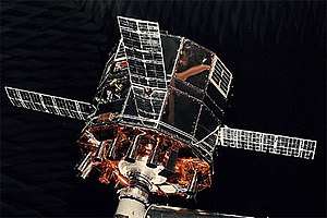
Solrad 10 was a 12-sided cylinder that measured 76 centimetres (30 in) in diameter and 58 centimetres (23 in) in height. Four symmetrically placed 17.8 by 53.3 centimetres (7.0 in × 21.0 in) solar cell panels, hinged at the central section of the structure, served as the elements of a turnstile antenna system. 18 solar sensors were mounted pointing parallel to the spin axis of the satellite, which pointed directly at the solar disk. The plane of rotation shifted about 1°/day so that a stellar detector mounted to point radially outward from the axis scanned the celestial sphere. Data from all detectors were stored in a 54 kbs core memory and telemetered on command to the NRL Satellite Operations Center at Blossom Point, Maryland. Data were also transmitted in real time at 137.710 MHz.[1]
Solrad 10 decayed and returned to the Earth on December 15, 1979.[3]
See also
References
- 1 2 3 4 "Solrad 10". NSSDCA. NASA Goddard Space Flight Center. Retrieved 19 June 2018.

- 1 2 McDowell, Jonathan. "Launch Log". Joanthan's Space Page. Retrieved 19 June 2018.
- 1 2 "EXPLORER 44 (SOLRAD-10)". n2yo.com. Retrieved 19 June 2018.
- 1 2 3 4 5 6 7 8 9 Peat, Chris. "Solrad 10 - Orbit". Heavens-Above GmbH. Retrieved 19 June 2018.
- ↑ Wade, Mark (2017). "Solrad". Encyclopedia Astronautica. Retrieved 19 June 2018.