Soleto
| Soleto | |
|---|---|
| Comune | |
| Comune di Soleto | |
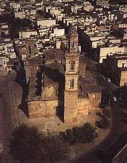 Plazza and town Church of Soleto | |
 Soleto Location of Soleto in Italy | |
| Coordinates: 40°11′N 18°12′E / 40.183°N 18.200°ECoordinates: 40°11′N 18°12′E / 40.183°N 18.200°E | |
| Country | Italy |
| Region |
|
| Province | Lecce (LE) |
| Area | |
| • Total | 29 km2 (11 sq mi) |
| Elevation | 91 m (299 ft) |
| Population (30 November 2014)[1] | |
| • Total | 5,523 |
| • Density | 190/km2 (490/sq mi) |
| Demonym(s) | Soletani |
| Time zone | UTC+1 (CET) |
| • Summer (DST) | UTC+2 (CEST) |
| Postal code | 73010 |
| Dialing code | 0836 |
| ISTAT code | 075076 |
| Patron saint | St. Anthony of Padua |
| Website | Official website |
Soleto (Griko: Sulìtu; Salentino: Sulìtu; Latin: Soletum) is a small Griko-speaking city located in the province of Lecce in Apulia, Italy. The town has a total population of 5,523 and is one of the nine towns of Grecìa Salentina.
History
In the 5th century, Soleto was elevated to the seat of a bishopric of the Byzantine Rite. In the Middle Ages it was ruled by Count Gjon Kastrioti II (the Roman numeral is related to the Kastrioti dynasty), son of the Albanian national hero Skanderbeg. In the 13th century the Angevine rulers of Naples chose the city as the capital of a county, later ruled by the Castro, Balzo, Orsini, Campofregoso, Castriota, Sanseverino, Carafa, and Gallarati-Scotti families, until feudal control was finally abolished in 1806. Soleto became part of the Neapolitan Republic of 1799 and was a center of the Carboneria during the Italian Risorgimento.
Soleto Map
The Soleto Map, the oldest geographical map in the Western world, was discovered in Soleto by Belgian archaeologist Thierry van Compernolle of Montpellier University on 21 August 2003.
Notable people
- Matteo Tafuri (1492–1582), philosopher, astrologer and physician.
See also
References
External links
- Soleto on Line (in Italian)
- Photogallery of Soleto (in English)

