Sobral Peninsula
Location of Nordenskjöld Coast.
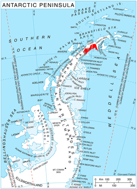
Sobral Peninsula (64°30′S 59°40′W / 64.500°S 59.667°WCoordinates: 64°30′S 59°40′W / 64.500°S 59.667°W) is a high and mainly ice-covered peninsula projecting from Nordenskjöld Coast in northern Graham Land, Antarctica. The feature is 11 nautical miles (20 km) long and 5 nautical miles (9 km) wide and projects southward between Larsen Inlet to the east and Mundraga Bay to the west. The name was applied by United Kingdom Antarctic Place-Names Committee (UK-APC) (1963) and derives from Cape Sobral at the south end of this peninsula.
References
![]()
This article is issued from
Wikipedia.
The text is licensed under Creative Commons - Attribution - Sharealike.
Additional terms may apply for the media files.