Smith Field (Arkansas)
| Smith Field | |||||||||||
|---|---|---|---|---|---|---|---|---|---|---|---|
 | |||||||||||
| Summary | |||||||||||
| Airport type | Public | ||||||||||
| Owner | City of Siloam Springs | ||||||||||
| Serves | Siloam Springs, Arkansas | ||||||||||
| Elevation AMSL | 1,191 ft / 363 m | ||||||||||
| Coordinates | 36°11′31″N 094°29′24″W / 36.19194°N 94.49000°WCoordinates: 36°11′31″N 094°29′24″W / 36.19194°N 94.49000°W | ||||||||||
| Runways | |||||||||||
| |||||||||||
| Statistics (2009) | |||||||||||
| |||||||||||
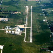
Smith Field (IATA: SLG, ICAO: KSLG, FAA LID: SLG) is a city-owned, public-use airport located three nautical miles (6 km) northeast of the central business district of Siloam Springs, a city in Benton County, Arkansas, United States.[1] According to the FAA's National Plan of Integrated Airport Systems for 2009–2013, it is categorized as a general aviation airport.[2]
Facilities and aircraft
Smith Field covers an area of 270 acres (110 ha) at an elevation of 1,191 feet (363 m) above mean sea level. It has one runway designated 18/36 with an asphalt surface measuring 4,997 by 75 feet (1,523 x 23 m).[1]
For the 12-month period ending July 31, 2009, the airport had 35,050 aircraft operations, an average of 96 per day: 99.9% general aviation and 0.1% military. At that time there were 42 aircraft based at this airport: 74% single-engine, 19% multi-engine, 2% jet and 5% ultralight.[1]
References
- 1 2 3 4 FAA Airport Master Record for SLG (Form 5010 PDF). Federal Aviation Administration. Effective 8 April 2010.
- ↑ National Plan of Integrated Airport Systems for 2009–2013: Appendix A: Part 1 (PDF, 1.33 MB). Federal Aviation Administration. Updated 15 October 2008.
External links
- Aerial image as of 4 April 2000 from USGS The National Map
- FAA Terminal Procedures for SLG, effective October 11, 2018
- Resources for this airport:
- FAA airport information for SLG
- AirNav airport information for KSLG
- ASN accident history for SLG
- FlightAware airport information and live flight tracker
- NOAA/NWS latest weather observations
- SkyVector aeronautical chart, Terminal Procedures