Smidovichsky District
| Smidovichsky District Смидовичский район (Russian) | |
|---|---|
.svg.png) Location of Smidovichsky District in the Jewish Autonomous Oblast | |
| Coordinates: 48°36′N 133°48′E / 48.600°N 133.800°ECoordinates: 48°36′N 133°48′E / 48.600°N 133.800°E | |
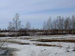 Landscape of Smidovichsky District, with the settlement of Volochayevka-2 visible on the horizon | |
.png) | |
|
| |
| Location | |
| Country | Russia |
| Federal subject | Jewish Autonomous Oblast[1] |
| Administrative structure (as of July 2011) | |
| Administrative center | settlement of Smidovich[1] |
| Inhabited localities:[1] | |
| Urban-type settlements[2] | 4 |
| Rural localities | 21 |
| Municipal structure (as of May 2010) | |
| Municipally incorporated as | Smidovichsky Municipal District[3] |
| Municipal divisions:[4] | |
| Urban settlements | 4 |
| Rural settlements | 2 |
| Statistics | |
| Area | 5,900 km2 (2,300 sq mi)[5] |
| Population (2010 Census) | 28,165 inhabitants[6] |
| • Urban | 67.5% |
| • Rural | 32.5% |
| Density | 4.77/km2 (12.4/sq mi)[7] |
| Time zone | VLAT (UTC+10:00)[8] |
| Official website | |
| Smidovichsky District on WikiCommons | |
| 2010 Census | 28,165[6] |
|---|---|
| 2002 Census | 28,193[9] |
| 1989 Census | 29,708[10] |
| 1979 Census | 28,114[11] |
Smidovichsky District (Russian: Смидо́вичский райо́н) is an administrative[1] and municipal[3] district (raion), one of the five in the Jewish Autonomous Oblast, Russia. It is located in the east of the autonomous oblast and borders Khabarovsk Krai (via the Tunguska River) in the north and east, China (via the Amur River) in the south, and Birobidzhansky District in the west. The area of the district is 5,900 square kilometers (2,300 sq mi).[5] Its administrative center is the urban locality (a settlement) of Smidovich.[1] As of the 2010 Census, the total population of the district was 28,165, with the population of Smidovich accounting for 18.2% of that number.[6]
Geography
The district stretches for 50 kilometers (31 mi) from north to south and for 125 kilometers (78 mi) from west to east. The terrain is low river plain, with the Amur and Tunguska Rivers wide and meandering along the district borders. Immediately to the east of the district is the city of Khabarovsk.
The climate is suited to agriculture, supporting buckwheat, corn, wheat, and vegetables.
Transportation
The Trans-Siberian Railway runs across northern length of the district, as does the Amur Highway (R297) from Chita to Khabarovsk.
References
Notes
- 1 2 3 4 5 Law #982-OZ
- ↑ The count of urban-type settlements may include the work settlements, the resort settlements, the suburban (dacha) settlements, as well as urban-type settlements proper.
- 1 2 Law #228-OZ
- ↑ Law #335-OZ
- 1 2 "Official website of Smidovichsky District" (in Russian). Smidovichsky District. Archived from the original on September 6, 2014. Retrieved January 23, 2017.
- 1 2 3 Russian Federal State Statistics Service (2011). "Всероссийская перепись населения 2010 года. Том 1" [2010 All-Russian Population Census, vol. 1]. Всероссийская перепись населения 2010 года (2010 All-Russia Population Census) (in Russian). Federal State Statistics Service. Retrieved June 29, 2012.
- ↑ The value of density was calculated automatically by dividing the 2010 Census population by the area specified in the infobox. Please note that this value is only approximate as the area specified in the infobox does not necessarily correspond to the area of the entity proper or is reported for the same year as the population.
- ↑ Правительство Российской Федерации. Федеральный закон №107-ФЗ от 3 июня 2011 г. «Об исчислении времени», в ред. Федерального закона №271-ФЗ от 03 июля 2016 г. «О внесении изменений в Федеральный закон "Об исчислении времени"». Вступил в силу по истечении шестидесяти дней после дня официального опубликования (6 августа 2011 г.). Опубликован: "Российская газета", №120, 6 июня 2011 г. (Government of the Russian Federation. Federal Law #107-FZ of June 31, 2011 On Calculating Time, as amended by the Federal Law #271-FZ of July 03, 2016 On Amending Federal Law "On Calculating Time". Effective as of after sixty days following the day of the official publication.).
- ↑ Russian Federal State Statistics Service (May 21, 2004). "Численность населения России, субъектов Российской Федерации в составе федеральных округов, районов, городских поселений, сельских населённых пунктов – районных центров и сельских населённых пунктов с населением 3 тысячи и более человек" [Population of Russia, Its Federal Districts, Federal Subjects, Districts, Urban Localities, Rural Localities—Administrative Centers, and Rural Localities with Population of Over 3,000] (XLS). Всероссийская перепись населения 2002 года [All-Russia Population Census of 2002] (in Russian). Retrieved August 9, 2014.
- ↑ Demoscope Weekly (1989). "Всесоюзная перепись населения 1989 г. Численность наличного населения союзных и автономных республик, автономных областей и округов, краёв, областей, районов, городских поселений и сёл-райцентров" [All Union Population Census of 1989: Present Population of Union and Autonomous Republics, Autonomous Oblasts and Okrugs, Krais, Oblasts, Districts, Urban Settlements, and Villages Serving as District Administrative Centers]. Всесоюзная перепись населения 1989 года [All-Union Population Census of 1989] (in Russian). Институт демографии Национального исследовательского университета: Высшая школа экономики [Institute of Demography at the National Research University: Higher School of Economics]. Retrieved August 9, 2014.
- ↑ "Всесоюзная перепись населения 1979 г. Национальный состав населения по регионам России. (All Union Population Census of 1979. Ethnic composition of the population by regions of Russia.)". Всесоюзная перепись населения 1979 года (All-Union Population Census of 1979) (in Russian). Demoscope Weekly (website of the Institute of Demographics of the State University—Higher School of Economics. 1979. Retrieved 2008-11-25.
Sources
- Законодательное Собрание Еврейской автономной области. Закон №982-ОЗ от 20 июля 2011 г. «Об административно-территориальном устройстве Еврейской автономной области». Вступил в силу через 10 дней после дня официального опубликования. Опубликован: "Биробиджанская звезда", №54, 29 июля 2011 г. (Legislative Assembly of the Jewish Autonomous Oblast. Law #982-OZ of July 20, 2011 On the Administrative-Territorial Structure of the Jewish Autonomous Oblast. Effective as of the day which is 10 days after the day of the official publication.).
- Законодательное Собрание Еврейской автономной области. Закон №228-ОЗ от 26 ноября 2003 г. «О статусе и границе Смидовичского муниципального района», в ред. Закона №760-ОЗ от 26 мая 2010 г. «О внесении изменений в некоторые Законы Еврейской автономной области». Вступил в силу через 10 дней после официального опубликования. Опубликован: "Биробиджанская звезда", №93, 23 декабря 2003 г. (Legislative Assembly of the Jewish Autonomous Oblast. Law #228-OZ of November 26, 2003 On the Status and Borders of Smidovichsky Municipal District, as amended by the Law #760-OZ of May 26, 2010 On Amending Various Laws of the Jewish Autonomous Oblast. Effective as of the day which is 10 days after the official publication.).
- Законодательное Собрание Еврейской автономной области. Закон №335-ОЗ от 2 ноября 2004 г. «О границах и статусе городских, сельских поселений в составе Смидовичского муниципального района», в ред. Закона №511-ОЗ от 29 июня 2005 г. «О внесении изменений в Закон ЕАО "О границах и статусе городских, сельских поселений в составе Смидовичского муниципального района"». Вступил в силу через 10 дней после дня официального опубликования. Опубликован: "Биробиджанер штерн", №92, 21 декабря 2004 г. (Legislative Assembly of the Jewish Autonomous Oblast. Law #335-OZ of November 2, 2004 On the Borders and Status of the Urban, Rural Settlements Within Smidovichsky Municipal District, as amended by the Law #511-OZ of June 29, 2005 On Amending the Law of the Jewish Autonomous Oblast "On the Borders and Status of the Urban, Rural Settlements Within Smidovichsky Municipal District". Effective as of the day which is 10 days after the day of the official publication.).
Administrative center: Birobidzhan • Rural localities | |||
| Districts | |||
| Towns | |||
| Urban-type settlements |
| ||