Slivna
| Slivna | |
|---|---|
 | |
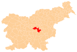
 Slivna Location in Slovenia | |
| Coordinates: 46°7′20.96″N 14°48′56.21″E / 46.1224889°N 14.8156139°ECoordinates: 46°7′20.96″N 14°48′56.21″E / 46.1224889°N 14.8156139°E | |
| Country |
|
| Traditional region | Styria |
| Statistical region | Central Sava |
| Municipality | Litija |
| Area | |
| • Total | 3.47 km2 (1.34 sq mi) |
| Elevation | 626.6 m (2,055.8 ft) |
| Population (2002) | |
| • Total | 136 |
| [1] | |
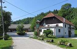
Slivna (pronounced [ˈsliːu̯na]) is a settlement west of Vače the Municipality of Litija in central Slovenia. The area was traditionally part of Styria and is now included with the rest of the municipality in the Central Sava Statistical Region.[2] The settlement is the Geometric Centre of the Republic of Slovenia.
The local church, built in the hamlet of Zgornja Slivna, is dedicated to Saint Agnes (Slovene: sveta Neža) and belongs to the Parish of Vače. It is a late 14th-century church that was restyled in the Baroque in the late 17th to early 18th centuries.[3]
References
External links
This article is issued from
Wikipedia.
The text is licensed under Creative Commons - Attribution - Sharealike.
Additional terms may apply for the media files.