Slickrock Trail
Coordinates: 38°34′53″N 109°31′10″W / 38.581365°N 109.51947°W

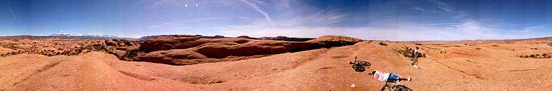
The Slickrock Trail, is a popular mountain biking destination with worldwide fame that is located in Grand County, Utah United States, just northeast of the city of Moab.[1][2][3][4][5] This 10.5-mile (16.9 km) loop[6][Note 1] takes intrepid riders over a landscape of "petrified" sand dunes and the eroded remnants of ancient sea beds. The Slickrock Trail is one of the more difficult rides in the Moab area, both technically and cardiovascularly, and is not suitable for novice riders.
Description

Part of the Sand Flats Recreation Area (which is managed through a partnership between Grand County and the Bureau of Land Management),[6] [Note 2] the Slickrock Trail was originally laid out in 1969 by Richard R. Wilson for use by Honda Trail 90s (before the mountain bike was invented), and the area is still open to such recreation today.[8][9][6][10][5] 4X4 and off-road enthusiasts will find a challenge on the nearby Hell's Revenge 4X4 Trail, which intersects the Slickrock Trail in several places.
The so-called "slickrock" sandstone, which forms the majority of the trail's surface, is not slick at all, but has a surface much like sandpaper. The rubber tires of a mountain bike or off-road motorcycle will grip readily to its surface on all but the steepest hills. The sandpaper texture is notorious for inflicting severe abrasion injuries. The name "slickrock" was given by early settlers of the area because their horses' metal shoes had difficulty gaining traction on the rock's sloping surfaces.[1][11][8] The same is true today for cyclists who use shoes with metal cleats while riding the Slickrock Trail. Slickrock also becomes very slick when wet.

In geological terms, the Slickrock Trail is not part of the actual "slickrock" formation. Rather, most of the outcrop that forms the trail is Navajo Sandstone. More commonly, the term "slickrock" has come to mean any expanse of sandstone with a surface level enough for walking or riding.
A minimal fee is required to enter the Sand Flats Recreation Area.[Note 2] Pit-toilets are available at the trailhead, but there is no drinking water available within the area.
Permitted trail activities include mountain biking, hiking, motorcycling. All four-wheeled vehicles are prohibited on the all of the Slickrock Trail, except those sections which intersect with the Hell's Revenge 4X4 Trail (which occurs about six time).[12][6]
Course
The Slickrock Trail consists of three main sections, an out-and-back lead-in (also known as a lollipop stick or a cherry stem), a 6.8-mile (10.9 km) loop, and an optional 2.3-mile (3.7 km) "practice loop". The practice loop is not necessarily any easier than the rest of the trail, just shorter and nearer to the trailhead. The lead-in, loop, and practice loop are clearly marked by white dashed lines to prevent riders from straying from the trail, becoming lost, or disturbing the fragile cryptobiotic soil through which the trail passes. There are also some sections marked with yellow dashes (near abrupt drop-offs or on narrow ledges) cautioning riders to be especially careful.[12][13][9][Note 3]
See also
![]()
Notes
- ↑ Actual length of the trial may vary as there are several alternate routes for the trail.[6] In addition to the main trail, there is a much shorter 2-mile (3.2 km) practice loop.[7]
- 1 2 As of October 2017, the fees to access the Sand Flats Recreation Area are $5.00 per day or $10.00 per week for vehicles and $2.00 per day or $5.00 per week for others (including bicycle, motorcycle, shuttle bus, etc.). While annual passes are also available, federal and state recreation passes are not accepted. Additional fees also apply for camping and vehicle trailers.[6]
- ↑ The trail's first recorded fatality was in May 1975, when a motorcyclist went off a cliff near the trail, falling 600 feet (180 m) to his death. As the incident was observed by a person fishing below, it apparently occurred on a drop-off near SR-128 and the Colorado River.[5]
References
- 1 2 "Slickrock Trail of the Sand Flats Recreation Area". visitutah.com. Salt Lake City: Utah Office of Tourism. Retrieved 17 Oct 2017.
- ↑ Bromka, Gregg. "Slickrock Moab Bike Trails". utah.com. Retrieved 17 Oct 2017.
- ↑ Barber, Jeff. "Slickrock". signletracks.com. Retrieved 17 Oct 2017.
- ↑ "Slick Rock Mountain Bike Trail".
- 1 2 3 Seal, Franklin (17 Mar 2017). "The little known history of Moab's Slickrock Trail". rimtours.com. Rim Tours. Retrieved 17 Oct 2017.
- 1 2 3 4 5 6 "The Slickrock Bike Trail & Sand Flats Recreation Area". discovermoab.com. Retrieved 17 Oct 2017.
- ↑ "The One and Only Slickrock Trail!". utahmountainbiking.com. Retrieved 17 Oct 2017.
- 1 2 Hafner, Marcia (Aug 2008). "The Slickrock Bike Trail - To the Abyss And Beyond". moabhappenings.com. Retrieved 17 Oct 2017.
- 1 2 Nicholson, Brian (27 Oct 2010). "Faith in friction: On Slickrock Trail, trust your tires and bring plenty of water". Deseret News. Salt Lake City: Deseret Digital Media. Retrieved 17 Oct 2017.
- ↑ "Slickrock Trail Guide: the Slickrock Trail". single-serving.com. Archived from the original on 4 Mar 2016. Retrieved 17 Oct 2017 – via web.archive.org.
- ↑ "Slickrock". trailforks.com. Retrieved 17 Oct 2017.
- 1 2 "Slickrock Bike Trail". grandcountyutah.net. Moab, Utah: Grand County. Retrieved 17 Oct 2017.
- ↑ "Slickrock (practice)". trailforks.com. Retrieved 17 Oct 2017.
External links
| Wikimedia Commons has media related to Slickrock Trail. |
- Sand Flats Recreation Area. Visitor guide and guide to bike trails.
- Slickrock Trail on UtahMountainBiking.com. Description, map, and GPS coordinates.
- Rim Tours. Mountain Bike Tour Operator in Moab.
- Slickrock Trail on Trailforks Map, photos & conditions
- Slickrock MTB Trail - The Most Famous Bike Trail on YouTube
- GoPro HD Mountain Biking Moab Slickrock Trail on YouTube