Slaytonville, Arkansas
| Slaytonville, Arkansas | |
|---|---|
| Unincorporated community | |
 Slaytonville, Arkansas  Slaytonville, Arkansas | |
| Coordinates: 35°06′38″N 94°26′19″W / 35.11056°N 94.43861°WCoordinates: 35°06′38″N 94°26′19″W / 35.11056°N 94.43861°W | |
| Country | United States |
| State | Arkansas |
| County | Sebastian |
| Elevation | 653 ft (199 m) |
| Time zone | UTC-6 (Central (CST)) |
| • Summer (DST) | UTC-5 (CDT) |
| Area code(s) | 479 |
| GNIS feature ID | 58634[1] |
Slaytonville is an unincorporated community in Sebastian County, Arkansas, United States.[1]
Notes
Municipalities and communities of Sebastian County, Arkansas, United States | ||
|---|---|---|
| Cities | 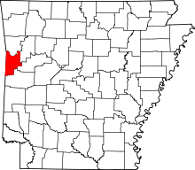 | |
| Towns | ||
| Unincorporated communities | ||
| Footnotes | ‡This populated place also has portions in an adjacent county or counties | |
This article is issued from
Wikipedia.
The text is licensed under Creative Commons - Attribution - Sharealike.
Additional terms may apply for the media files.