Skorpa, Troms
 View of Skorpa | |
 | |
 Skorpa Location of the island  Skorpa Skorpa (Norway) | |
| Geography | |
|---|---|
| Location | Troms, Norway |
| Coordinates | 69°55′54″N 21°41′24″E / 69.9317°N 21.6899°ECoordinates: 69°55′54″N 21°41′24″E / 69.9317°N 21.6899°E |
| Area | 8.26 km2 (3.19 sq mi) |
| Highest elevation | 307 m (1,007 ft) |
| Highest point | Varden |
| Administration | |
|
Norway | |
| County | Troms |
| Municipality | Kvænangen Municipality |
| Demographics | |
| Population | 0 (2018) |
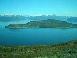
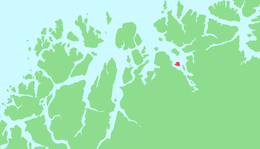
Skorpa (Norwegian) or Skárfu (Northern Sami) is an uninhabited island in Kvænangen Municipality in Troms county, Norway. The 8.26-square-kilometre (3.19 sq mi) island is located in the middle of the Kvænangen fjord, south of the island of Spildra. The last permanent resident of the island moved off the island around 1980, and the island has had no permanent inhabitants since then. It is only accessible by boat.[1]
History
The island was the historical center of the municipality of Kvænangen. The municipal government and Skorpa Church were located on the island. The Skorpa prisoner of war camp was located on the island during World War II. The municipal government moved to Burfjord on the mainland during the 20th century and the island's population continued to decline until around 1980, when the island became uninhabited.[1]
See also
References
- 1 2 Isachsen, Harald; Thorsnæs, Geir, eds. (2018-04-18). "Skorpa - øy i Troms". Store norske leksikon (in Norwegian). Kunnskapsforlaget. Retrieved 2018-08-02.