Skala-Podilska
| Skala-Podilska Skala | ||
|---|---|---|
 | ||
| ||
 Skala-Podilska Location in Ukraine | ||
| Coordinates: 48°51′9″N 26°11′40″E / 48.85250°N 26.19444°E | ||
| Country |
| |
| Oblast | Ternopil | |
| Raion | Borshchiv | |
| Government | ||
| • Mayor | Victor P. Myronchuk | |
| Area | ||
| • Total | 1.52 km2 (0.59 sq mi) | |
| Population (2015) | ||
| • Total | 4,258 | |
| • Urban density | 2,786/km2 (7,220/sq mi) | |
| Time zone | UTC+2 (EET) | |
| • Summer (DST) | UTC+3 (EEST) | |
| Look up Skala in Wiktionary, the free dictionary. |
Skala-Podilska (Ukrainian: Скала-Подільська, translit. Skala-Podilʹsʹka; Russian: Скала-Подольская, translit. Skala-Podol'skaya; Polish: Skała; Yiddish: סקאַל, translit. Skal; Hebrew: סקאלה, translit. S'kalah) or Skala upon Zbruch (Ukrainian: Скала-над-Збручем, translit. Skala-nad-Zbruchem; Polish: Skała Nad Zbruczem; German: Skala am Zbrucz) is an urban-type settlement in Ternopil Oblast, Ukraine over the Zbruch River.
It was, at one time, named simply "Skala", however the town compounded its name, variously, to "Skala upon Zbruch", in order to distinguish itself from another town with that same name.[1]
History
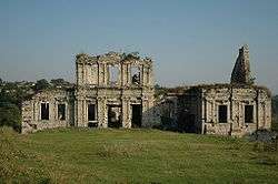
Geographically the town is located in the western Podolia, hence the name. It is located not far where Zbruch falls into Dniester. The town is first mentioned after its fortress that was built in 1360s - 1370s. After the Kingdom of Galicia-Volhynia was torn apart between the Kingdom of Poland and the Grand Duchy of Lithuania, the city was secured by the Lithuanian family of Koriatovychi, but later in the 15th century it was passed to the Polish Crown with which it stayed until the partition of Poland in the late 18th century. After that it became part of the Habsburg Monarchy. Because of this precarious location, it has a history of ethnic diversity and has been, during periods of war or political unrest, particularly susceptible to turmoil.[2][3][4]
Prior to World War I, Skala-Podilska was part of the province of Galicia, on the eastern border of the Austro-Hungarian Empire.[5]
In 1919—after World War I, the collapse of the Austro-Hungarian Empire, and the Polish-Ukrainian War—Skala upon Zbruch became part of eastern Poland. It was populated mostly by Ukrainians, Poles, and Jews.[6][7] The town bordered the Soviet Union, from which it was separated only by the Zbrucz River.[8][9]
Prior to World War II, Skala-Podilska was home to a significant Jewish population.[10] Cossacks from the east frequently crossed over the river to raid the town, focusing their violence and destruction on Skala's Jewish population.[11][12][13]
In 1939—toward the beginning of World War II—the Soviet Union invaded Skala upon Zbruch and forcibly "resettled" many of the Ukrainians, Poles, and Jews to remote areas of the Soviet Union. Due both to the forceble nature of these "resettlements" and to the severe conditions of the resettlement regions, these locales have sometimes been characterized as "being arrested and sent to the gulag"[14] (see Gulag#During World War II").
In the summer-autumn of 1941, the territories annexed by the Soviet Union were overrun by Nazi Germany in the course of the initially successful German attack on the USSR. Most of the Jews from Skala upon Zbruch perished during the Holocaust in Borshchiv Ghetto .[15]
After the defeat of Nazi Germany, Skala-Podilska officially became part of the Soviet Union as a result of the territorial changes of Poland after World War II. It became part of Ukraine on July 16, 1990, when Ukraine declared its independence from the Soviet Union.
References
- ↑ Skala on the River Zbrucz, website hosted by JewishGen Inc
- ↑ Skala on the River Zbrucz, website hosted by JewishGen Inc
- ↑ Encyclopedia of Jewish Communities in Poland, Volume II, Pinkas Hakehillot Poland Series, Yad Vashem, see chapter titled "Skala (Skala Podolskaya)"
- ↑ Nancy Sinkoff, Out of the Shtetl, Making Jews Modern in the Polish Borderlands, (Brown Judaic Studied, 336)
- ↑ Skala on the River Zbrucz, website hosted by JewishGen Inc
- ↑ Encyclopedia of Jewish Communities in Poland, Volume II, Pinkas Hakehillot Poland Series, Yad Vashem, see chapter titled "Skala (Skala Podolskaya)"
- ↑ Fanya Gottesfeld Heller, Love In A World Of Sorrow: A Teenage Girl's Holocaust Memoirs (Devora Publishing, 2005)
- ↑ Max Mermelstein (Weidenfeld), et al., Skala, (Skala Benevolent Society, New York, Tel Aviv, 1978)
- ↑ Encyclopedia of Jewish Communities in Poland, Volume II, Pinkas Hakehillot Poland Series, Yad Vashem, see chapter titled "Skala (Skala Podolskaya)"
- ↑ Max Mermelstein (Weidenfeld), et al., Skala, (Skala Benevolent Society, New York, Tel Aviv, 1978)
- ↑ Max Mermelstein (Weidenfeld), et al., Skala, (Skala Benevolent Society, New York, Tel Aviv, 1978)
- ↑ Encyclopedia of Jewish Communities in Poland, Volume II, Pinkas Hakehillot Poland Series, Yad Vashem, see chapter titled "Skala (Skala Podolskaya)"
- ↑ Fanya Gottesfeld Heller, Love In A World Of Sorrow: A Teenage Girl's Holocaust Memoirs (Devora Publishing, 2005)
- ↑ Franciszek Proch, Poland's Way of the Cross, New York 1987 P.146
- ↑ Max Mermelstein (Weidenfeld), et al., Skala, (Skala Benevolent Society, New York, Tel Aviv, 1978)
Coordinates: 48°51′00″N 26°12′00″E / 48.850000001°N 26.200000001°E
Additional External Resources
- Paintings of Jewish Skala before the war by Shoshana Eden
http://shoshana-eden.co.il/Eng
- Bibliography for Skala Researchers
- Tracy Abraham, To Speak for the Silenced (Dvorah Publishing Company, 2007)
- Skala Monument in Holon, Israel
- Skala on the River Zbrucz, edited by Skala Research Group and Skala Benevolent Society, 2010, translation of original Skala Yizkor Book, see http://www.shtetlinks.jewishgen.org/SkalaPodol/SkalaYizkorBook.html
| Cities | ||
|---|---|---|
| Urban-type settlements | ||
| Villages |
| |