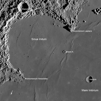
Sinus Iridum
 Annotated Sinus Iridum by LRO | |
| Coordinates | 45°01′N 31°40′W / 45.01°N 31.67°WCoordinates: 45°01′N 31°40′W / 45.01°N 31.67°W |
|---|---|
| Diameter | 249 km |
| Eponym | Bay of Rainbows |
Sinus Iridum (Latin for "Bay of Rainbows") is a plain of basaltic lava that forms a northwestern extension to the Mare Imbrium on Earth's moon. It is surrounded from the northeast to the southwest by the Montes Jura range. Close to the bay in the range in the northwest is the crater Bianchini; west of the bay is the crater Sharp. The protruding part of the range at the southwest end is named Promontorium Heraclides, while that at the northeast end is called Promontorium Laplace. This bay and the surrounding mountains is considered one of the most beautiful features on the Moon, and is a favorite among lunar observers.
Sinus Iridum is formed from the remains of a large impact crater, which was subsequently flooded with basaltic lava, inundating the "sea" wall. The bay itself does not contain any notable impact craters, but does include the satellite crater Heraclides E in the south, Laplace A along the eastern edge, and Bianchini G in the north. The surface is level, but is marked by a number of wrinkle ridges (dorsa).
The selenographic coordinates of the bay's center are 45.01° N, 31.67° W, and the diameter is 249 km.[1]
History

One of the first image including video by JAXA's probe Kaguya were taken and recorded alongside Montes Jura and Mare Imbrium and the promontories of Heraclides and Laplace on October 31, 2007. The spacecraft took the world's first high definition image data of the Moon from an altitude about 100 kilometers away from the Moon on October 31, 2007.[2]
It was the planned landing site of Chang'e 3, China's 2013 lunar exploration mission, which instead landed nearby in Mare Imbrium.
Names
The feature was given the Latin name for the Bay of Rainbows by Giovanni Riccioli, whose 1651 nomenclature system has become standardized.[3] Earlier lunar cartographers had given the feature different names: Michael van Langren's 1645 map calls it "Sinus Geometricus", the "Bay of Geometry" referring to its geometric shape.,[4] and Johannes Hevelius called it "Sinus Apollonis" after Apollo, a bay in the north of Africa.[5]
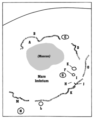
Satellite craters
By convention these features are identified on lunar maps by placing the letter on the side of the crater midpoint that is closest to Promontorium Heraclides.
| Heraclides | Latitude | Longitude | Diameter |
|---|---|---|---|
| A | 40.9° N | 34.2° W | 6 km |
| E | 42.9° N | 32.7° W | 4 km |
| F | 38.5° N | 33.7° W | 3 km |
The following satellite craters are associated with the Promontorium Laplace.
| Laplace | Latitude | Longitude | Diameter |
|---|---|---|---|
| A | 43.7° N | 26.8° W | 9 km |
| B | 51.3° N | 19.8° W | 5 km |
| D | 47.3° N | 25.5° W | 11 km |
| E | 50.3° N | 19.8° W | 6 km |
| F | 45.6° N | 19.8° W | 6 km |
| L | 51.7° N | 21.0° W | 7 km |
| M | 52.2° N | 19.9° W | 6 km |
External links
- Wood, Chuck (2006-08-20). "Out the Porthole". Lunar Photo of the Day. Retrieved 2016-09-18. , excellent earth-based image of Sinus Iridum and vicinity
- Nemiroff, R.; Bonnell, J., eds. (8 February 2008). "The Bay of Rainbows". Astronomy Picture of the Day. NASA.
- On the Shore of the Bay of Rainbows - Lunar Reconnaissance Orbiter page with images
- High resolution video by Seán Doran of an overflight of Sinus Iridum, based on LRO data; this video also passes over Sinus Iridum about halfway through (see album for more)
References
| Wikimedia Commons has media related to Sinus Iridum. |
- ↑ "Gazetteer of Planetary Nomenclature - Sinus Iridum". United States Geological Survey. International Astronomical Union (IAU). 18 October 2010. Retrieved 2018-01-30.
- ↑ "Mare Imbrium on HDTV". Kaguya. October 31, 2007. Archived from the original on March 6, 2016.
- ↑ Ewen A. Whitaker, Mapping and Naming the Moon (Cambridge University Press, 1999), p.211.
- ↑ Ewen A. Whitaker, Mapping and Naming the Moon (Cambridge University Press, 1999), p. 197.
- ↑ Ewen A. Whitaker, Mapping and Naming the Moon (Cambridge University Press, 1999), p. 202.