Promontorium Laplace
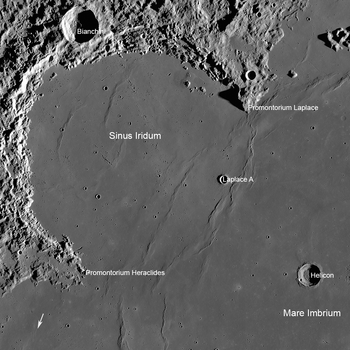
Promontorium Laplace is a raised mountainous cape situated at the end of Montes Jura in Mare Imbrium on the near side of the Moon. Its selenographic coordinates are 46.0° N, 26.0° W and it is 2600 meters high. It forms the northeast boundary of the bay of Sinus Iridum.
North of the mountain range (headland) is Maupertuis crater.
It is named after Pierre Simon marquis de Laplace, an 18th-century French astronomer, mathematician, and physicist.
History
One of the first image including video by JAXA's probe Kaguya were taken and recorded alongside with nearby Sinus Iridium, Montes Jura and Mare Imbrium on October 31, 2007. The spacecraft took the world's first high definition image data of the Moon from an altitude about 100 kilometers away from the Moon on October 31, 2007.[1]
References
- ↑ "Mare Imbrium on HDTV". Kaguya. October 31, 2007. Archived from the original on March 6, 2016.
External links
- Wood, Chuck (2006-08-20). "Out the Porthole". Lunar Photo of the Day. Retrieved 2016-09-18. , excellent earth-based image of Sinus Iridum and vicinity, including Promontorium Laplace